J Navig Port Res > Volume 47(4); 2023 > Article
S-201 표준기반의 항로표지 정보관리에 대한 연구

요 약

항로표지는 안전한 항해를 위해 중요한 도구로 항로표지가 제공하는 다양한 정보는 매우 중요하다. 항로표지 정보를 효율적으로활용하기 위한 표준화된 항로표지 정보에 대한 수요는 점차 증가하고 있으며, 이를 위해 국제항로표지협회에서는 항로표지 정보관리 표준인S-201을 제정하고 회원국에게 적용을 권고하고 있다. 그러나 우리나라는 항로표지법에 따라 항로표지를 정의하고 그 정보를 관리하고 있기에 국제적인 표준인 S-201 표준에 따른 정의 및 정보관리의 필요성은 더욱 커지고 있다. 이에 본 연구에서는 국제항로표지협회의 권고에 따라 S-201 표준을 적용한 항로표지 정보 관리 방안을 제시하고자 하였다. 이를 위해 국제항로표지협회의 항로표지 정보 분류기준과 우리나라의 분류기준을 비교한 후, S-201 표준을 적용한 우리나라 항로표지 정보관리방안을 제시하였다. 이러한 연구 결과는 전세계적으로 정보 활용이 용이한 표준화된 디지털 항로표지 정보를 관리하는 데 중요한 기초자료로 활용될 것이라고 사료된다.

ABSTRACT

Aids to Navigation (AtoN) is an important tool for safe navigation, and the variety of information provided by AtoN is invaluable. The demand for standardized AtoN information for efficient utilization is gradually increasing, and for this purpose, the International Association of Lighthouse Authorities (IALA) has developed S-201, a standard for the management of AtoN information, and recommends its application to member countries. Notably, since Korea defines AtoNs and manages the information according to the Aids to Navigation Act, the need for definition and information management according to the S-201 standard, an international standard, is even greater. Therefore, in this study, according to the recommendation of IALA, we aimed to suggest a way to manage AtoN information by applying the S-201 standard. To this end, after comparing the classification criteria of the AtoN information of the IALA, and that of Korea's classification standards, Korea's AtoN information management plan applying the S-201 standard was presented. The results of this study provide important basic data for managing standardized digital AtoN information that is easy to use worldwide.

1. 서론

국제적으로 다양한 분야에서 디지털화 및 표준화의 중요성이 높아지고 있으며, 해양수산 분야에서도 이러한 흐름에 맞추어 국제항로표지협회(International Association of Lighthouse Authorities, IALA)에서는 국제적인 항로표지 정보 교환을 위해 S-201 표준을 개발하였으며, IALA 회원국으로 표준 적용을 권고하고 있다. 국제적으로 통용되는 S-201 표준은 2019년 70차 IALA 이사회에서 처음 승인된 이후 지속적으로 버전이 업데이트되고 있다 (IALA, 2022). 이러한 표준 적용의 중요성은 IALA가 비정부 기구(Non-Governmental Organization, NGO)에서 정부 간 기구(Intergovernmental Organization, IGO)로 전환되면서 더욱 커지고 있다(2024년에 IGO로 전환될 예정). 하지만 현재 우리나라는 항로표지 법에 따라 항로표지 정보를 관리할 뿐만 아니라 분산하여 관리하고 있어, 효율적인 정보관리에 어려움이 많은 실정이다 (Kim, 2022). 이에 항로표지 정보관리 체계의 재개편이 필요한 시점이며, 그 관리 방법은 국제적인 표준인 S-201 표준을 고려하여 설계될 필요가 있다.
항로표지 정보와 관련된 선행연구로는 항로표지사고 분류체계의 재정립에 관한 연구 및 S-201 기반의 항로표지 빅데이터 구축에 대한 연구 등이 있다 (Moon., 2023, Kim, 2022). Moon(2023)은 지난 23년(00-22년)간 발생한 항로표지사고 및 S-201 표준 분석을 통해 항로표지사고의 원인을 내·외부적 요인으로 구분하였으며, 사고유형은 3가지로 구분하였다. 그리고 Kim(2022)은 전세계의 항로표지 정보 수집 및 관리를 위한 S-201 기반의 항로표지 빅데이터 구축방안 제시하였다. 이처럼 최근에 효율적인 정보관리를 위한 체계화된 정보구분 기준과 관련된 연구가 많이 진행되고 있으며, 본 연구에서는 항로표지 정보의 표준화 및 효율적인 항로표지 정보관리를 위하여 국제 항로표지 정보 분류 현황 분석을 통해 효율적으로 항로표지 정보가 관리될 수 있는 방안을 제시하고자 한다.
우리나라의 항로표지 기본정보는 항로표지 전산관리시스템(여수지방해양수산청 소관)으로 관리되고 있다. 그러나 이 시스템은 개발 이후, 상황에 따라 여러 기능이 유동적으로 추가되었기 때문에 시스템의 재정비가 필요한 시점이다. 현재는 항로표지법에 따라 항로표지 정보를 관리하고 있으나, 정보의 정확성과 책임성을 보장할 수 있는 국제기준인 S-201 표준에 따라 정보를 관리하는 시스템으로 전환될 필요가 있다. 또한, 품질관리에 한계가 있는 담당자가 수동으로 모든 데이터를 입력하는 방식이 아닌 가급적 수동 입력을 최소화하는 방식으로 전환되어야 한다. 따라서 본 논문에서는 S-201 표준 기반의 항로표지 정보관리 방안을 제시함과 동시에, 새로운 정보관리 방법에 따라 개발 중인 항로표지 정보관리 시스템의 입력체계 변환방안을 함께 제시하고자 한다.

2. 항로표지 정보 분류 현황

IALA에서는 해상부표식(Maritime Buoyage System, MBS)으로 항로표지를 분류하고 있으며, 항로표지 정보교환 표준(S-201 Aids to Navigation Information)을 기준으로 항로표지 정보를 구분 및 관리하고 있다. 반면 우리나라에서는 분류와 관리기준을 구분하지 않고, 항로표지법으로 항로표지를 분류하고 해당 정보를 관리하고 있다.
국제적으로 통용되는 항로표지 분류 기준인 해상부표식과 국제 항로표지 정보교환 표준 간에도 항로표지를 구분하는 방식에 차이가 있으며, 우리나라 항로표지법과도 항로표지를 구분하는 방식에 차이가 있다.

2.1해상부표식(Maritime Buoyage System, MBS) 분류 현황

IALA 해상부표식은 항로표지에 대한 국제적인 지침으로 1970년대부터 활용되고 있으며, 위치와 관계없이 항해하는 모든 선원이 자신의 위치를 고정하고 위험을 피할 수 있도록 하는 것을 목적으로 한다 (IALA, 2023). 해상부표식에서는 항로표지 기능에 초점을 맞추어 항로표지를 구분하며, 구체적으로 가항수로의 한계를 나타내는 측방 표지, 안전한 수역의 방위를 나타내는 방위표지, 암초 등의 장애물이 있음을 알리는 고립 장애 표지, 가항수역을 나타내는 안전수역 표지 등으로 분류한다 (Table 1).

2.2 S-201 분류 현황

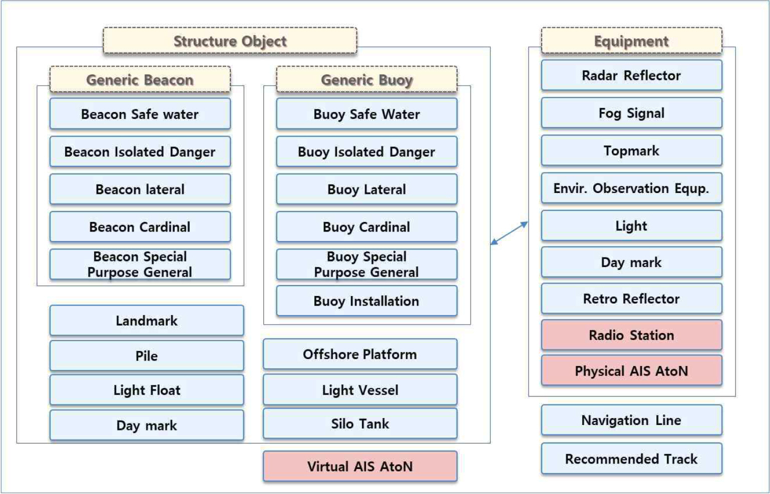
IALA에서는 효율적인 항로표지의 정보교환을 위하여 항로표지 정보 교환 표준인 S-201을 개발하였으며, 2019년 Ed. 1.0.0 승인 이후 2022년에 Ed. 1.1.0으로 개정되는 등 지속적으로 개정되고 있다 (IALA, 2022). IALA S-201 표준에서는 IALA 해상부표식과는 달리 물리적으로 구분되는 항로표지의 구성요소를 기준으로 항로표지를 구분하고 있는 것이 특징이며, 크게 5가지로 항로표지를 구분한다. 항행 보조장치, 장비, 구조물, 입표, 부표로 구분하여 항로표지 정보를 관리하며, 구체적인 내용은 표 2, 3에 기술하였다(Table 2, 3).
S-201 표준에서는 항로표지를 구조물과 장비의 결합으로 항로표지를 정의하며, 국내와는 다르게 표지 구조물에 대한 정보를 별도로 관리하지 않는다는 특징이 있다 (Fig. 1).

2.3 항로표지법에 따른 국내 분류 현황

항로표지법 제2조 1에 따르면, 항로표지란 항행하는 선박에 대하여 등광ㆍ형상ㆍ색채ㆍ음향ㆍ전파 등을 수단으로 선박의 위치ㆍ방향 및 장애물의 위치 등을 알려 주는 항행보조시설로서 광파표지, 형상표지, 음파표지, 전파표지 및 특수신호표지 등 해양수산부령으로 정하는 것을 의미한다 (MOF, 2019). 그러나 항행 보조를 위한 장치, 시스템, 그리고 서비스까지 포함하는 IALA의 ‘AtoN’과 국내에서 사용되는 ‘항로표지’ 용어는 범위의 차이가 있다.
또한, 기능의 초점을 맞춘 IALA 해상부표식, 물리적으로 구분되는 요소를 기준으로 구분하는 IALA S-201 표준과는 달리, 국내에서는 빛, 형상, 음향 등 의미 전달 수단을 기준으로 항로표지를 구분하고 그 정보를 관리하고 있다. 물리적인 구분으로는 ‘장비’, ‘구조물’, ‘표지’로 항로표지 정보를 구분하며, 현재 국내에서 관리하는 주요 구조물 정보는 ‘부표 구조물’, ‘등대 구조물’, ‘입표(등표) 구조물’, ‘조류신호 구조물’로 ‘파일 구조물’, ‘해상 구조물’, ‘사일로탱크 구조물’ 정보도 포함하는 S-201 표준의 Structure 분류와 차이가 있다. 특히, 국제적으로는 구분하지 않는 방파제 등대를 별도로 구분하여 관리하는 것이 특징이다 (Table 4).

3. S-201 표준에 따른 항로표지 정보관리의 필요성

2022년 9월, 국제수로기구(International Hydrographic Organization, IHO)와 IALA의 정기 워크숍에서는 S-201 표준 활용에 대한 합의가 있었다(IALA, 2022). 기존에 공문으로 주고받았던 항로표지 변경 정보를 S-201 표준을 적용한 디지털 데이터로 주고받을 것이라는 합의가 있었으며, 이는 회원국들에 S-201 표준 적용을 촉구하는 계기가 되었다 (Fig. 2). 두 국제기구 간의 합의를 통해 S-201 표준 적용의 중요성이 더욱 커졌으며, 이를 통해 우리나라뿐만 아니라 다른 회원국들과의 데이터 교환 등의 상호 운용성을 향상하는 데 큰 역할을 할 것으로 사료 된다. 이러한 국제적인 표준화 및 디지털화 흐름과 안전한 해상교통환경을 보장하기 위해 항로표지 정보관리 시 IALA S-201 표준을 준용해야 할 필요가 있다.
우리나라도 IALA S-201 표준에 따라 항로표지 정보관리를 한다면 국제적인 데이터 협력 기반을 구축할 수 있을 것으로 기대된다.

4. 항로표지 정보관리시스템으로의 변환

4.1 항로표지 전산관리시스템 현황

항로표지 전산관리시스템(이하 전산관리시스템)은 여수지방해양수산청에서 관리하는 시스템으로 장비용품, 표지정보, 이력카드, 부표, 항로표지 정비, 통계정보에 대한 관리 등 해양수산부 직원들이 사용하는 항로표지 관리 업무 시스템이다 (MOF, 2019). 전산관리시스템은 초기 확장이 쉽지 않게 개발되어, 실무자들의 요구가 있을 때마다 필요 기능이 추가되어 시스템이 유연하게 확장되지 못했다는 한계점이 있다. 또한, 사용자가 직접 수동으로 데이터를 입력하기 때문에 입력 과정에서 발생하는 많은 오류로 인하여 데이터의 신뢰성이 보장되지 못한다는 문제점이 있다. 더불어 항로표지의 모든 장비, 구조물 정보를 관리하는 것이 아닌 일부 장비와 구조물 정보만 등록·관리하여 항로표지의 모든 데이터를 관리하고 있지 못하며, 항로표지 관리 운영시스템(항로표지 상태정보 관리 시스템)과도 연계되지 않아 데이터의 원활한 교환이나 활용에 한계가 있다 (Kim. 2019).
또한, 전산관리시스템에는 ‘구조물’ 개념이 없으며, ‘부표구조물’ 정보만 관리되고 있어 부표를 제외한 표지에 대한 정보를 관리하고 있지 않다. 따라서 표지에 장착된 장비(등명기, 태양전지, 축전지, 충방전조절기 등)에 대한 정보만 관리하고 있어, 장비가 다른 표지로 교체되어 장착되는 경우 정보관리의 어려움이 있다. 따라서 S-201 표준을 적용하여 구조물을 상위개념으로 하여 ‘부표 구조물’, ‘등대 구조물’, ‘입표 구조물’, ‘파일 구조물’, ‘사일로탱크 구조물’, ‘해상 구조물’로 구분하여 구조물을 관리하여야 한다.

4.2 항로표지 정보관리시스템 현황

전산관리시스템의 노후화 및 표준화된 디지털 정보로 항로표지 정보를 관리하기 위하여 항로표지 정보관리시스템(이하 정보관리시스템)이 개발 중이다. 정보관리시스템의 주요 특징은 S-201 표준을 준용한 정보관리체계 변환, 데이터 자동 입력체계 개발 등이다. 구체적으로 S-201 표준을 준용하여 장비, 구조물, 표지에 대한 체계를 개선하였으며, 그 결과 신규 장비용품을 8개 추가하여 기존 장비용품 6개와 더불어 총 14개의 장비용품을 관리하고자 한다 (Table 5).
또한, 27개로 구분하여 관리하던 표지 정보를 표지 입력값 분석 및 S-201 표준 적용을 통해 13개의 표지 정보로 재분류하였다. 등부표, 부표, 입표, 교량 등 항로표지 중 큰 비중을 차지하는 정보는 전산관리시스템과 같게 관리하고자 하며, 무인등대, 유인등대, 방파제등대와 같이 하나의 표지 종류로 결합이 가능한 정보는 하나의 항목으로 결합하여 신규 표지로 재분류하였다. 또한 전산관리시스템 분석 결과 다수의 장비용품들이 표지 정보로 관리되고 있어, 해당 항목들은 장비용품으로 분류하였다 (Table 6, 7).
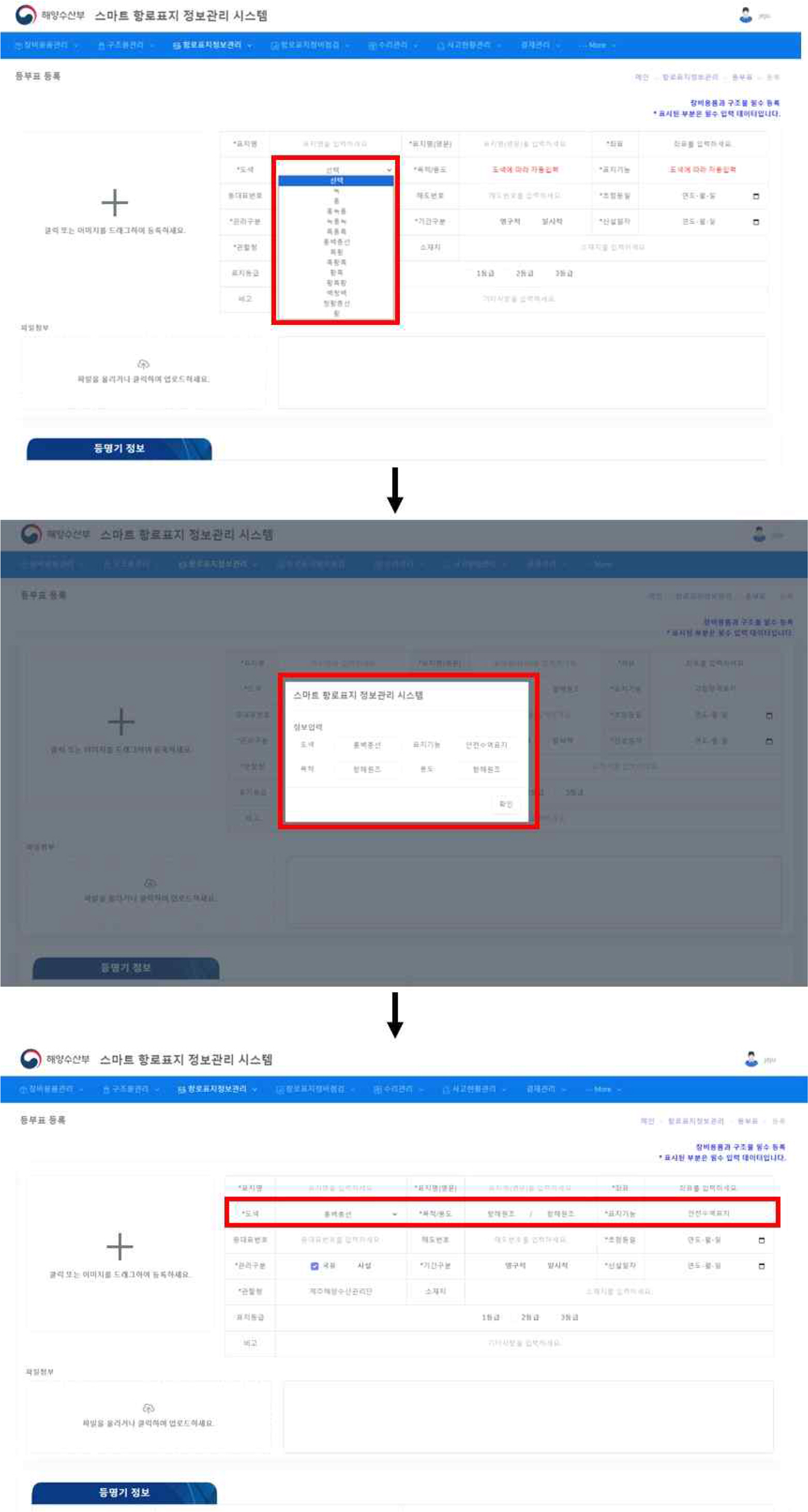
많은 정보를 이력카드에서 관리하는 전산관리시스템과는 다르게, 정보관리시스템에서는 항로표지 기본 입력 데이터 분석을 통하여 데이터 수동 입력을 최소화하도록 하고자 하였다. 구체적으로 레이더비콘의 표지 부호는 규격화된 신호 중 하나를 선택하도록 하였으며, 표지를 등록할 때 도색을 선택하면 그에 따라 목적과 용도, 그리고 표지 기능이 자동으로 선택되도록 하였다 (Fig. 3).
표지 대부분은 목적과 용도가 ‘항해원조’이며, 침선표시(청황종선)와 특수표지(황)만 목적이 ‘특수목적’으로 설정된다. 또한, 특수표지는 용도가 다양하므로, 표지의 용도를 직접 선택할 수 있도록 하였다. 이렇듯 자동 입력이 가능한 데이터는 자동 입력이 가능하게 하였으며, 표지명, 좌표, 신설일자 등 표지에 따라 입력해야 정보는 전산관리시스템과 동일하게 사용자가 입력하도록 하였다.

5. 결론

항로표지는 선박 운항의 안전과 효율성을 증진하는데 중요한 항행보조 도구로, 선박이 안전하고 원활하게 항행할 수 있도록 도와주는 중요한 시설이다. 그러나 우리나라는 IALA와 다른 방법으로 항로표지를 분류하고 있어, 표준화된 디지털 데이터 구축을 통한 효율적인 정보관리를 위해서는 국제 표준에 따른 항로표지 정보관리가 필요하다. 이를 위해 IALA S-201 표준을 적용한 항로표지 정보관리 방안을 도입하여 항로표지 정보를 체계적으로 관리하고 국제적 상호 운용에 이바지하는 것이 필수적이라고 사료된다.
본 연구에서는 현행 항로표지 구분 기준 및 IALA S-201 및 MBS에 따른 항로표지 정의 및 분류 현황을 분석한 후, IALA S-201 표준에 따른 항로표지 정보관리 방안을 제안하였다. 국제적으로 통용되는 IALA S-201 표준 적용을 통한 항로표지 정보관리는 국내에서 관리하는 표지의 주요 정보를 S-201 GML 포맷의 데이터로 제작하는데 기본자료로 활용될 것이라고 기대되며, 이를 통해 디지털 기능 통보(S-124/S-125)가 가능할 것으로 사료된다.

Acknowledgments

이 논문은 2023년 해양수산부 재원으로 해양수산과학기술진흥원의 지원을 받아 수행된 연구임 (해양 디지털 항로표지정보협력시스템 개발(3/5) (20210650))

Fig. 1.
IALA S-201 AtoN information product specification (Moon, 2023)
KINPR-2023-47-4-220f1.jpg
Fig. 2.
Data flow between the S-201, S-124 and S-125 product specifications (IALA, 2022)
KINPR-2023-47-4-220f2.jpg
Fig. 3.
Automatic setting of purpose and use and mark function according to paint color selection
KINPR-2023-47-4-220f3.jpg
Table 1.
Classification of AtoN according to MBS
Classification Type Explanation
Lateral Mark Port Hand mark The mark represents right side of the cover is navigable waters
Starboard Hand mark The mark represents left side of the marker is navigable waters
Preferred Channel to Port The mark represents left side of a navigable waterway is the navigable waterway
Preferred Channel to Starboard The mark represents right side of a navigable waterway is a navigable waterway
Cardinal Mark East cardinal The mark represents safer navigable water lies to the east
West cardinal The mark represents safer navigable water lies to the west
South cardinal The mark represents safer navigable water lies to the south
North cardinal The mark represents safer navigable water lies to the north
Isolated Danger Mark - The mark erected on, or moored on or above, an isolated danger which has navigable water all around it.
Safe Water Mark - The marks serve to indicate that there is navigable water all around the mark.
Special Mark - The marks are used to indicate a special area or feature whose nature may be apparent from reference to a chart or other nautical publication.
Emergency Wreck Mark - New dangers may be marked with an Emergency Wreck mark.

source: R1001 The IALA Maritime Buoyage System (MBS) Ed 2.0, IALA, 2023

Table 2.
Classification of AtoN according to S-201
Classification Explanation
Aids To Navigation A visual, acoustical, or radio device, external to a ship, designed to assist in determining a safe course or a vessel’s position, or to warn of dangers and/or obstructions.
Equipment The implements used in an operation or activity.
Structure Object Something (such as a house, tower, bridge, etc) that is built by putting parts together and that usually stands on its own.
Generic Beacon A fixed artificial navigation mark that can be recognised by its shape, colour, pattern, topmark or light character, or a combination of these. It may carry various additional aids to navigation.
Generic Buoy A floating object moored to the bottom in a particular (charted) place, as an aid to navigation or for other specific purposes.

source: R1001 The IALA Maritime Buoyage System (MBS) Ed 2.0, IALA, 2023

Table 3.
Details classification of AtoN according to S-201
Classification Type Explanation
Aids to navigation Recommended track A track recommended to all or only certain vessels.
Navigation line A navigation line is a straight line extending towards an area of navigational interest and generally generated by two navigational aids or one navigational aid and a bearing.
Equipment Topmark A characteristic shape secured at the top of a buoy or beacon to aid in its identification.
Light A luminous or lighted aid to navigation.
Fog signal A warning signal transmitted by a vessel, or aid to navigation, during periods of low visibility. Also, the device producing such a signal.
Retro-reflector A means of distinguishing unlighted marks at night. Retro-reflective material is secured to the mark in a particular pattern to reflect back light.
Radar reflector A device capable of, or intended for, reflecting radar signals.
Meteorological environment observation equipment Equipment that collects or measures marine weather information
Daymark The identifying characteristics of an aid to navigation which serve to facilitate its recognition against a daylight viewing background.
Radar transponder beacon A transponder beacon transmitting a coded signal on radar frequency, permitting an interrogating craft to determine the bearing and range of the transponder.
Structure object Offshore platform A permanent offshore structure, either fixed or floating, used in the production of oil or natural gas.
Light vessel A distinctively marked vessel anchored or moored at a charted point, to serve as an aid to navigation. By night, it displays a characteristic light(s) and is usually equipped with other devices, such as fog signal, submarine sound signal, and radio-beacon, to assist navigation.
Pile A long heavy timber or section of steel, wood, concrete, etc. forced into the earth which may serve as a support, as for a pier, or a free standing pole within a marine environment.
Silo/tank An enclosed container, used for storage.
Landmark A prominent object at a fixed location which can be used in determining a location or a direction.
*Light house A distinctive structure on or off a coast exhibiting a major light designed to serve as an aid to navigation.
Light float A boat-like structure used instead of a light buoy in waters where strong streams or currents are experienced, or when a greater elevation than that of a light buoy is necessary.
Generic Beacon Beacon, special purpose /general A special purpose beacon is primarily used to indicate an area or feature, the nature of which is apparent from reference to a chart, Sailing Directions or Notices to Mariners (UKHO NP 735, 5th Edition). Beacon in general: A beacon whose appearance or purpose is not adequately known.
Beacon, lateral A lateral beacon is used to indicate the port or starboard hand side of the route to be followed. They are generally used for well defined channels and are used in conjunction with a conventional direction of buoyage.
Beacon, cardinal A cardinal beacon is used in conjunction with the compass to indicate where the mariner may find the best navigable water. It is placed in one of the four quadrants (North, East, South and West), bounded by inter-cardinal bearings from the point marked.
Beacon, isolate danger An isolated danger beacon is a beacon erected on an isolated danger of limited extent, which has navigable water all around it.
Beacon, safe water A safe water beacon is a prominent specially constructed object forming a conspicuous mark as a fixed aid to navigation or for use in hydrographic survey.
Generic Buoy Buoy, installation An installation buoy is a buoy used for loading tankers with gas or oil.
Buoy, lateral A lateral buoy is used to indicate the port or starboard hand side of the route to be followed. They are generally used for well defined channels and are used in conjunction with a conventional direction of buoyage.
Buoy, cardinal A cardinal buoy is used in conjunction with the compass to indicate where the mariner may find the best navigable water. It is placed in one of the four quadrants (North, East, South and West), bounded by inter-cardinal bearings from the point marked.
Buoy, safe water A safe water buoy is used to indicate that there is navigable water around the mark.
Buoy, isolated danger A isolated danger buoy is a buoy moored on or above an isolated danger of limited extent, which has navigable water all around it.
Buoy, special purpose general A special purpose buoy is primarily used to indicate an area or feature, the nature of which is apparent from reference to a chart, Sailing Directions or Notices to Mariners (UKHO NP 735, 5th Edition). Buoy in general: A buoy whose appearance or purpose is not adequately known.
mooring warping facility The equipment or structure used to secure a vessel.
buoy emergency wreck marking New dangers may be marked with an Emergency Wreck mark.

* Light house’s supertype is Landmark

source: IALA S-201 Feature Catalogue
Table 4.
Classification of AtoN according to Aids to Navigation Act
Classification Type Explanation
Lights marks Lighthouse (manned/unmanned) A tower, or substantial building or structure, erected at a designated geographical location to carry a signal light and to assist marine navigation.
Light beacon A navigational marker that indicates dangerous reefs, shallow water areas, and no-navigational zones at sea.
Leading light A lighthouse consisting of two or more towers at regular intervals along a straight course to guide ships sailing in a narrow channel to a safe course.
Illuminating light A structure with a floodlight installed to illuminate a reef or a protrusion at the end of a breakwater to alert ships navigating in the vicinity to the location of an obstruction.
Sector light A light presenting different characters (usually different colours) over various parts of the horizon of interest to marine navigation.
Light pile It is a light ficture installed on a simple pole or structure and is usually installed temporarily for breakwater construction in small ports, harbors, and fishing harbors.
Bridge lights A light placed on a bridge or pier to indicate the presence of navigable waters, which is the body of water beneath the bridge, or a pier in the navigation channel.
Vessel traffic light A traffic light is a navigational marking facility used to control the flow of vessel traffic in a harbor or approach to a harbor
Light buoy A buoy, a structure anchored to the seabed and floating to indicate the location of safe waters and obstacles such as reefs, and a navigation mark equipped with lanterns.
Spar buoy A fixed buoy that does not move, usually with a mouth. A buoy placed to maximize the width of a navigation channel, such as a narrow waterway.
LANBY A buoy, commonly a discus buoy, designed to carry a light, usually of high luminous intensity and at a height in excess of 10 metres above the water level, as an aid to navigation.
Light ship A ship that serves as a ligthhouse
Visual mark Beacon These are installations to mark the location of reefs, outcrops, etc.
Leading mark Navigation marks used as components of a leading-line or range.
Bridge mark A sign that protects the bridge facility through which ships pass and is installed for the safe passage of ships.
Vessel traffic mark It is placed to attract the attention of the navigator and to be readable at an actionable distance. They are intended to ensure safe and smooth traffic.
Buoy A floating, and moored, artificial navigation mark. It can be recognized by means of its shape, colour, pattern, topmark or light character, or a combination of these. It may carry various additional aids to navigation.
Sound mark Electric horn A device on a ship that announces its position by sounding a loudspeaker with low-frequency oscillations caused by an electrical device.
Air siren An acoustic signaling device on a signage facility or vessel that can sound a horn by compressed air when visibility is poor due to fog, rain, snow, etc.
Motor siren A sound signal emitter using the periodic escape of compressed air through a rotary shutter.
Diaphone A fog signal operating on the principle of periodic release of compressed air controlled by the reciprocating motion of a piston operated by compressed air.
Radio mark Radar beacon A device whose radiations enable a craft to determine its own direction or position relative to the beacon by means of its own radar equipment.
DGNSS Detailed information about a specific DGNSS station.
LORAN-C Admiralty List of Radio Signals, Volume 2: Radio Aids to Navigation, Satellite Navigation Systems, Legal Time, Radio Time Signals and Electronic Position Fixing Systems
Special mark Marine weather signal mark It is a navigation marker that provides local marine and weather information in real time by installing equipment to observe wave height, wave direction, wave period, wind direction, wind speed, temperature, humidity, etc. at navigation marking facilities in ports and coastal waters nationwide.
Tidal current signal AtoN In straits with strong currents, it measures the direction, speed, and current of the current and provides it to ships via wired or wireless broadcast.
AIS AtoN It is a sign installed on maritime transportation facilities such as manned and unmanned lighthouses, lighthouses, buoys, and buoys to support navigation safety.

Source : Ministry of Oceans and Fisheries(2019), IALA Dictionary

Table 5.
Information management system vs. Computerized management system (for Equipment)
Computerized management system Information management system remarks
The machine that lights the lighthouse The machine that lights the lighthouse identical
Radar beacon Radar beacon
Storage battery Storage battery
Solar battery Solar battery
Solar regulator Solar regulator
RTU RTU
- Fog signal
Meteorological signal equipment
AIS
Tidal current signal observation equipment
Daymark
Rectifier
Topmark
Radar reflector
Table 6.
Information management system vs. Computerized management system (for Information management)
Computerized management system Information management system remarks
Lighted buoy Lighted buoy identical
Lighted beacon Lighted beacon
Buoy Buoy
Beacon Beacon
Light pile Light pile
Bridge (light) Bridge (light)
Bridge (daymark) Bridge (daymark)
Tidal current signal AtoN Tidal current signal AtoN
Vessel traffic mark Vessel traffic mark
Unmanned lighthouse lighthouse
Manned lighthouse
Breakwater lighthouse
Marine observation AtoN Marine structure
Marine structure light
AtoN AIS (physical) V-AIS
AtoN AIS (virtual)
LORAN-C GNSS
VTS
DGPS
- Silotank mark
Electric horn - manage as an equipment
Air siren -
Motor siren -
leading light -
Illuminating light -
Navigational traffic signal light -
Direction light -
Table 7.
Computerized management system vs. Information management system
Computerized management system Information management system
Classification applicable marks mark information mark type mark / equipment
Unmanned (Breakwater lighthouse) breakwater lighthouse / manned lighthouse / unmanned lighthouse / light beacon / beacon / light pile / protector Marks light / leading liaght / sector light / AtoNAIS(physical) / marine observation AtoN / vessel traffic light / marine structure light / vessel traffic mark / AtoNAIS (virtual) structure structure lighthouse
light(standard/magnit ude) eq uipment light
light(standard/other than magnitude) mark lighthouse
power distribution eq uipment battery/ solar battery/ battery charge
power distribution mark lighthouse
(light) buoy buoy / light buoy structure structure buoy
mooring equipment mark light buoy, buoy
operation completion ship operation management
light(standard/magnitude) equipment light
light(standard/other than magnitude) mark lighted buoy
power distribution equipment battery/ solar battery/ battery charge
weather condition mark buoy/lighted buoy
Racon Racon transmitter equipment racon
antenna
ground connection
Tidal current signal AtoN Tidal current signal AtoN facility equipment tidal current signal equipment
light mark tidal current signal AtoN
tidal current signal equipment equipment tidal current signal equipment
power utilities equipment tidal current signal equipment
Bridge mark Bridge mark structure structure pile
light mark bridge (light)
Fog signal air siren / horn / motor siren organ equipment fog signal
compressor
fog signal
switch and time limiter

References

[1] International Association of Marine Aids to Navigation and Lighthouse Authorities, International Dictionary of Marine Aids to Navigation, https://www.iala-aism.org/wiki/dictionary.
[2] International Association of Marine Aids to Navigation and Lighthouse Authorities2022), IALA S-201 Product Specification Edition 1.1.0.
[3] International Association of Marine Aids to Navigation and Lighthouse Authorities2022), Joint IHO/IALA Workshop S-100/S-200 Product Sepcification Development & Portrayal Report.
[4] International Association of Marine Aids to Navigation and Lighthouse Authorities2023), R1001 The IALA Maritime Buoyage System (MBS) Edition 2.0.
[5] Kim, Y, Oh, SW and Jeon, M(2022), “A Study on Construction of Aids to Navigation Big Data Based on S-201”, Journal of Korean Navigation and Port Research, Vol. 46, No. 5, pp. 409-418.
[6] Kim, T, Oh, SW, Kim, Y and Hwang, S(2019), ““Research on the development of an information management system””, Proceedings of the Korean Institute of Navigation and Port Research Conference.
[7] Ministry of Oceans and Fisheries2019), Law of Aids to Navigation.
[8] Moon, BS, Kim, TG, Song, CU and Kim, YJ(2023), “A Study on the Re-establishment of the Accident Classification for Aids to Navigation”, Journal of Korean Navigation and Port Research, Vol. 47, No. 3, pp. 128-133.


ABOUT
BROWSE ARTICLES
FOR CONTRIBUTORS
Editorial Office
C1-327 Korea Maritime and Ocean University
727 Taejong-ro, Youngdo-gu, Busan 49112, Korea
Tel: +82-51-410-4127    Fax: +82-51-404-5993    E-mail: jkinpr@kmou.ac.kr                

Copyright © 2024 by Korean Institute of Navigation and Port Research.

Developed in M2PI

Close layer
prev next