


1. Introduction
In the Fourth Industrial Revolution era, and as part of the Korean New Deal, many artificial intelligence (AI)-based marine and fishery studies are being conducted, such as the Maritime Autonomous Surface Ships(MASS) study and studies concerned with fishery management. In particular, global research related to digitization and standardization of marine information is being actively conducted in response to the rapidly changing marine environment, involving smart ports, smart containers, and smart aids to navigation (AtoN). For example, the S-200 series information exchange standards have been developed for efficient and systematic provision and management of AtoN data, in collaboration with the International Association of Marine Aids to Navigation and Lighthouse Authorities (IALA). AtoN aids ship navigation and ship/obstacle location via light, sound, and radio waves. The role of AtoNs is changing with the development of smart AtoNs, as an information platform supporting marine traffic environments (by collecting and analyzing information from existing navigation facilities, among other cooperative systems). AtoN information is important for maritime safety management, as it is a key indicator of maritime traffic flow and conditions. In addition to various sensors attached to the AtoN, the AtoN itself can generate big data, including information related to various management tasks such as checking and replacing the AtoN, and bringing it to the surface. In the course of a single day, AtoNs can generate an enormous amount of data. As such, given the increasing importance of AtoN-based information for maritime and fishery operations, as well as the large amount of data requiring processing and dissemination, proper management of AtoN big data is necessary. Currently, information aiding navigation in Korea, such as that obtained and stored by AtoNs, is managed by computerized management systems, such as that of the Yeosu Regional Office of Oceans and Fisheries, while status information is stored and managed by AtoN management and operation systems, such as those of the Regional Office of Oceans and Fisheries and National Maritime PNT Office. Despite recent revisions to S-201, which is the AtoN information exchange standard, many countries still manage AtoN data according to their own guidelines. This is problematic because there are various formats of AtoN data, depending on the management guidelines of each country; moreover, in numerous cases multiple organizations manage this data within a single country, making access and utilization more difficult. A standardized data format is required for data compatibility and convergence, to allow for meaningful and efficient evaluation and exchange of big data for AtoNs among users. In this study, we propose a plan for collecting, processing, and integrating AtoN big data based on the S-201 standard.
Currently, to construct big data aiding navigation, the IALA issues a questionnaire on AtoNs to individual countries, in an attempt to understand the current status of AtoNs and analyze global trends. This questionnaire covers all AtoNs, including those of the Vessel Traffic Service (VTS). It is requested that member states complete the questionnaire every 2-4 years. This questionnaire is a very powerful and unique tool for collecting and analyzing global AtoN data. However, the inconsistent 2-4-year questionnaire distribution cycle makes it somewhat difficult to determine the current status. Here, we examine the current status of the IALA survey, which is the only tool currently available for constructing AtoN big data, and attempt to identify the information that most requires management and the best methods to do so. Based on the results, we present a method for constructing S-200-based AtoN big data involving three key steps.
2. Status of the IALA Questionnaire
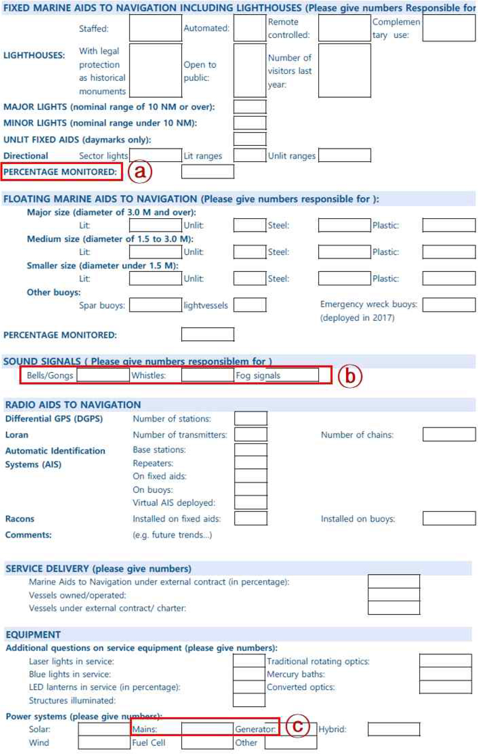
To understand the current status of AtoN data worldwide, the IALA issues the IALA Questionnaire to collect AtoN-related information from member countries every 2-4 years, as stated above. When the questionnaire was first introduced, the goal was to conduct the survey biennially; however, due to the low response rate and absence of an organization to conduct/oversee the survey, the questionnaire was issued inconsistently (every 2-4 years). The questionnaire consists of various questions related to AtoNs, such as the respondentŌĆÖs affiliated organizations, the roles of those organizations in maritime navigation assistance, and ŌĆ£fixed and floatingŌĆØ AtoN information. The questionnaire is detailed in Table 1.
Most of the questionnaire items are numeric, although there are also many questions requiring a ŌĆśyesŌĆÖ or ŌĆśnoŌĆÖ response (e.g., questions about quality management, such as performance indicators and ISO certification, and the role of the respondent organization). However, due to the lack of definition of terms in the questionnaire, the same term may be interpreted differently depending on the country and respondent. Additionally, in some cases, the interpretation of questions and terms is particularly difficult, if not impossible. Such issues are believed to be the main reason for the low response rate to the IALA Questionnaire.
In particular, for a question from the 2017 survey regarding who is in charge of navigation indicators, the responses ŌĆ£directly responsibleŌĆØ and ŌĆ£nationalŌĆØ were in fact the same (Fig. 1).
The difficulties related to the survey questions are believed to arise from interpretation issues. For example, the survey respondent may be in charge of a state-owned AtoN, the interpretations of the questioner and respondent may differ due to the lack of definition of the term ŌĆ£directly responsibleŌĆØ, and there may be no privately owned AtoN. Also, the fact that the survey results are the same for all countries indicates that the questionnaire needs to be updated.
The majority of the survey questions concern the current status of AtoNs. However, many questions are difficult to answer without current data, and due to different standards being used by individual countries and the presence of poorly defined terms (Fig. 2). Thus, completing the questionnaire is not an easy task.
Regarding IALA members, there are 325 organizations in 92 countries (as of May 22, 2022). About 30 % of members complete the questionnaire every year, which is the only tool available at present for evaluating AtoN globally, as stated above. However, the difficulty of questionnaire completion, and the low and unreliable response rate, prevent the information collected from being used for constructing big data for AtoNs. Thus, a new survey, or new methods for acquiring the necessary AtoN data, is required.
In the IALA Questionnaire, basic information classified as ŌĆ£fixed marine AtoNŌĆØ, ŌĆ£floating marine AtoNŌĆØ, ŌĆ£signal signalsŌĆØ, ŌĆ£radio AtoNŌĆØ, and ŌĆ£equipmentŌĆØ. Here, we present a method for constructing big data for AtoNs comprising three major steps, described in the following.
Regarding IALA members, there are 325 organizations in 92 countries (as of May 22, 2022). About 30% of members complete the questionnaire every year, which is the only tool available at present for evaluating AtoN globally, as stated above. However, the difficulty of questionnaire completion, and the low and unreliable response rate, prevent the information collected from being used for constructing big data for AtoNs. Thus, a new survey, or new methods for acquiring the necessary AtoN data, is required.
In the IALA Questionnaire, basic information classified as ŌĆ£fixed marine AtoNŌĆØ, ŌĆ£floating marine AtoNŌĆØ, ŌĆ£signal signalsŌĆØ, ŌĆ£radio AtoNŌĆØ, and ŌĆ£equipmentŌĆØ. Here, we present a method for constructing big data for AtoNs comprising three major steps, described in the following.
3. Stepwise approach to constructing AtoN big data based on S-201
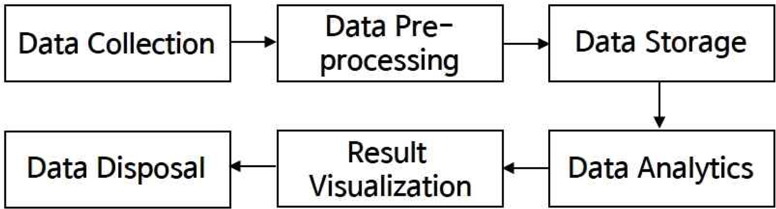
Big data is constructed via the following process: data collection, pre-processing, and storage. The stored data are then analyzed, visualized, and disposed of (Fig. 3). The core method for constructing big data is data standardization (i.e., pre-processing). In this study, as stated above, we propose a method for constructing big data aiding navigation by applying the S-201 standard. The S-201 is an international standard for exchanging AtoN information established by the IALA. This standard is applied for the creation and distribution of datasets, to enable the exchange of information between AtoNs installed in the sea or along the coast for safe navigation of ships. This standard was based on the S-100 standard of the International Hydrographic Organization; S-201 has been updated continuously since the release of version 1.0.0 in 2019.
In the three-step process to construct AtoN big data mentioned above, the S-201 standard is applied to standardize and digitize the acquired AtoN analog data to aid navigation. In the S-201 standard, AtoN information is divided into a structural part (corresponding to the surface) and an equipment part. This standard covers all types of navigation signals, such as light waves, shapes, sound waves, and radio waves, and has the advantage of being easily expandable as needed. The Geography Markup Language (GML) data format for information exchange is used by AtoN information management and collection agencies; data can be produced and transmitted in GML data format according to the S-201 standard.
In Korea, the total number of AtoN is 6,043, of which 3,310 are national owned (as of 22.10.23). In addition, there are 53,815 equipment, and the equipment that accounts for the largest proportion is storage batteries (44.5 %). More than 50,000 equipment and products are managed in Korea alone, and a vast amount of AtoN information has been managed around the world. Therefore, it is necessary to enable the utilization of AtoN big data through systematic data construction and management.
3.1 Design of the AtoN DB based on S-201
The first step for constructing S-201-based AtoN big data is to design a DB based on this standard. The PostgreSQL DB of the ŌĆ£S-201 testbedŌĆØ can store GML datasets (Fig. 4). S-201 DB Schema is composed of ŌĆ£catalogsŌĆØ, ŌĆ£featuresŌĆØ, ŌĆ£boundedbyŌĆØ, ŌĆ£dataset identification infromationŌĆØ, etc. centered on the ŌĆ£datasetŌĆØ. The data types of ŌĆ£lowercornerŌĆØ and ŌĆ£uppercornerŌĆØ of ŌĆ£boundedbyŌĆØ class are geometry, and most data types except for this are composed of varchar, integer, and float.
PostgreSQL is a powerful object-relational open-source DB that provides users with the ability to create various arbitrary DB objects, such as operators and extensions, to support unstructured data. In addition, the JavaScript Object Notation(JSON) data type is used as the ŌĆ£officialŌĆØ data type, allowing various functions and operations to be executed via the SQL, such as processing data according to an extensible schema.
An AtoN DB was developed with the object structure of the S-200 data model, to prevent performance degradation both when inputting large amounts of data in S-201 GML and Excel format, and when extracting data in S-201 GML format. In addition, to prevent performance degradation during object information query, which is required for symbol mapping, the AtoN DB should allow for continuous improvement of the DB schema. Figure 4 shows the DB schema designed based on the S-201 standard.
Another important consideration when designing an AtoN DB is compatibility with the Maritime Resource Name (MRN) service. The MRN is the only system available for identifying marine services/resources, and can be used to manage AtoN data.
A DB based on the S-201 standard compatible with the MRN service could be built using List of Lights information. Although the precise information provided by the List of Lights depends on the type of AtoN, it provides basic information allowing attribute linkage, as well as information on specific AtoN features. The floating AtoN, which is the most common type, uses a lighted beacon (Table 3).
The IALA focuses on both VTS and AtoN information. The S-201 standard used for big data construction can also be applied for management of VTS data. In this study, the VTS questionnaire was analyzed, and an S-100-based VTS system and data model providing information on operation status were designed. The VTS data model is composed around two feature types (ŌĆ£VTS_SurveyŌĆØ, ŌĆ£Competent AuthoritiesŌĆØ). ŌĆ£VTS_SurveyŌĆØ consists of basic information about VTS such as VTS name, type, number of sectors, and record information. And ŌĆ£Competent AuthoritiesŌĆØ consists of information on authorities, such as the number of competent authorities and whether or not to appoint VTS authorities. These two features consist of both simple (basic details, classification codes, VTS name and type, etc.) and complex (VTS equipment, service quality records, etc.) data types (Fig. 5). The initial AtoN DB is intended to deal with both simple (MRN and AtoN type) and complex (survey date, management organization information) information, based on the VTS questionnaire.
3.2 Linkage of S-201-based with the IALA AtoN portal
The second step is to link the S-201-based AtoN DBs of member countries with the IALA AtoN portal. The IALA AtoN portal is an information linkage system that will collect, manage, and analyze global AtoN DB information. It is scheduled for operation in the year 2026.
In this step, using the initial DB built in the previous step, IALA members will request DB updates based on the S-201 standard. In some countries, entities such as ATONIS: Aids to Navigation Information System (of the United States Coast Guard) and the Syst├©me dŌĆÖInformation de Positionnement des Aides (of the Canadian Coast Guard) have begun construction of S-201-based DBs; it is expected that more member countries will participate in this development phase within the next few years.
Linking S-201-based DBs with the IALA AtoN portal allows the latter to perform various statistical analysis functions related to fixed and floating AtoNs, and their associated radio signals, according to various standards. In particular, a Web-based geographic information system (GIS) with a spatial analysis function can be applied for mapping and cross-validation.
3.3 Updating S-201-based DBs
The last step is to update the AtoN DBs of member countries in association with the IALA AtoN portal. In this step, IALA member countries will apply the S-201 standard for management of time-series AtoN data. This will facilitate identification of global trends in AtoNs, including their general status and position, to aid maritime navigation. Furthermore, statistical analysis of global auxiliary AtoN big data could inform international policy and technology development.
If most IALA member countries apply the S-201 standard to manage AtoN data, information exchange would be possible between departments and the Hydrographic Bureau, and among countries, without the need for data processing (thus improving efficiency). In this manner, more meaningful statistical analyses could be performed.
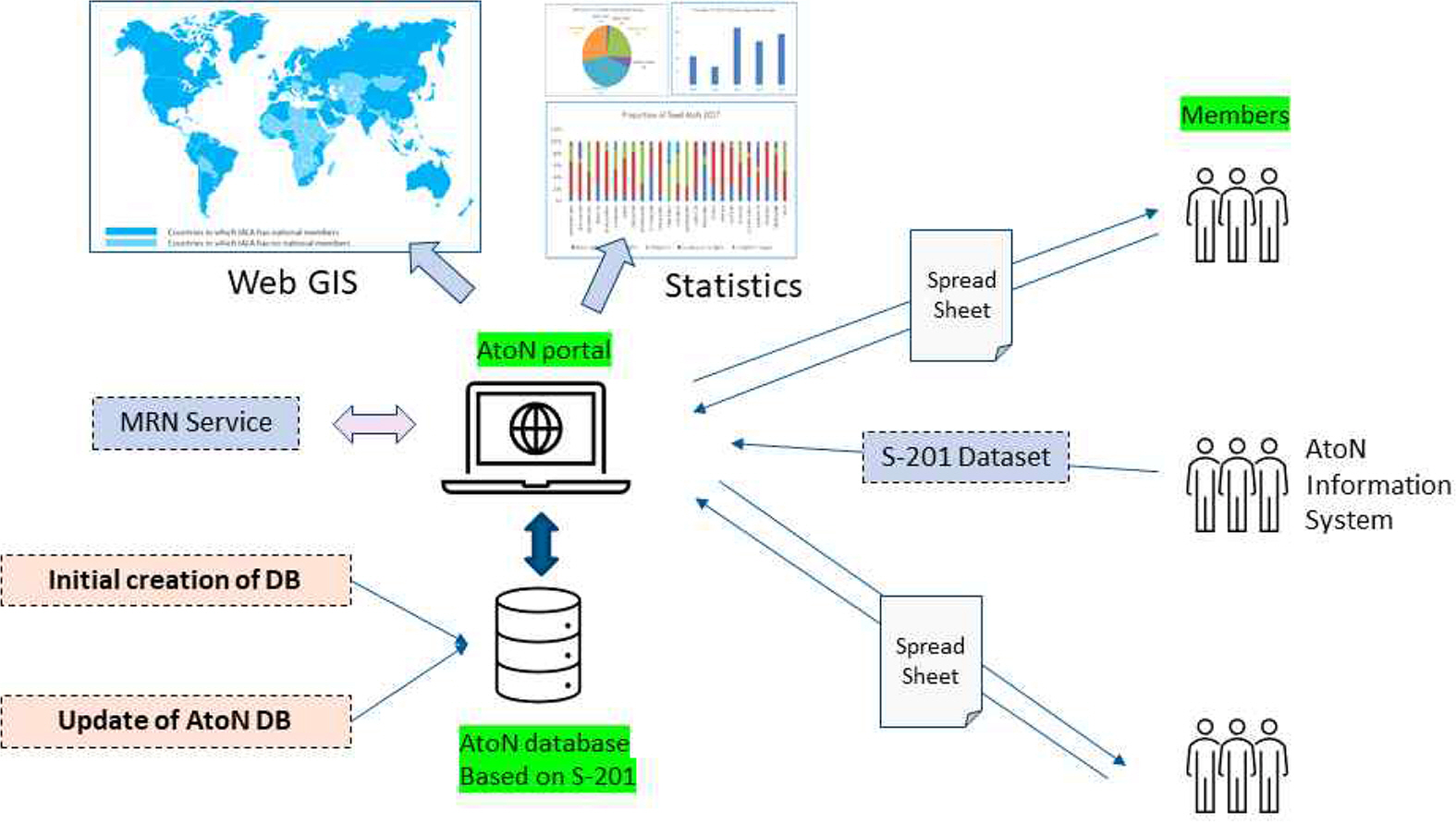
IALA AtoN portal system-compatible S-201-based DBs could be operated in conjunction with the MRN service to aid navigation. As stated above, AtoN big data can be standardized based on S-201, or spreadsheets provided by IALA member countries (Fig. 6). This would aid various Web-based GIS statistical analyses.
4. Conclusion
Recently, perceptions of data have changed, and the amount of open-access public data has increased. Previously, access to data was restricted for security reasons. More organizations are now disclosing data, leading to issues with data management, utilization, and storage. More accurate and efficient data collection and information exchange schemes are needed.
The main focus of all research is data acquisition. However, big data for AtoNs obtained via the IALA Questionnaire have not yet produced meaningful results, due to the difficulty of completing the questionnaire and low response rate; these limitations are linked to a lack of understanding of the survey questions, or different interpretations thereof among respondents. Therefore, in this study, a method of constructing the AtoN big data through DB modeling was presented in order to utilize the AtoN information efficiently. Specifically, the method of reconstructing the existing AtoN data to the S-201 standard, storing it in the DB and linking it with the IALA AtoN portal, was proposed in three steps. In the first step, an S-201-based DB aiding navigation was constructed using the List of Lights. In the second step, member countriesŌĆÖ DBs are linked with the IALA AtoN portal; this action will likely be undertaken by advanced IALA countries. In the third step, instead of surveying the AtoN data with an IALA questionnaire, the AtoN DB of each country and the DB of IALA AtoN portal are linked in order to investigate the AtoN data automatically without a separate response process. Through this, member countries update time series data for various statistical analyses and feedback with the aid of a Web-based GIS service. This will also allow for cross-validation of the data with map-based statistical analyses. Currently, it is almost impossible to check the current AtoN status and related statistics around the world, and only the domestic data managed by each country can be checked. Each country manages the AtoN information according to the standards of the respective country. As a result, interpretation of the same terms asked in the IALA questionnaire have different responses. If AtoN information is managed with the S-201 standard, it is thought that ambiguity about terms and questions will be eliminated because data structures are produced, stored, and managed based on the same standards. In other words, rather than managing each countryŌĆÖs subjective AtoN data, it is managed with the same data standard worldwide, making it possible to collect usable data, which is an important process in big data analysis. This does not mean that there is a large amount of data, but this means that the amount of available data is large. It is thought that it will be possible to analyze the trends of AtoN around the world, which was difficult with the IALA questionnaire.
To deal with the enormous amount of data generated by AtoNs globally on an hourly basis, we introduce a method to build AtoN DBs based on S-201, for linkage with the IALA AtoN portal. With further development of the IALA AtoN portal and establishment of S-201-based AtoN DBs in many countries, we believe that AtoN data collection, management, and dissemination will be improved. Verification of the DB will be done through a ŌĆ£S-201 testbedŌĆØ in further study. Moreover, rapid analysis of maritime environments could be achieved, as well as analysis of the current status of AtoNs to improve security/safety at sea, facilitate decarbonization efforts, and provide the infrastructure necessary for the introduction of smart ships.


 PDF Links
 PubReader
 ePub Link
 Full text via DOI
 Download Citation
 Print
Print


