

1. Introduction
In an event of a ship emergency, a rapid decision making by captain is necessary to minimize property damages and casualties. To do this, accurate and objective information such as the ship's condition, surrounding marine environment, expected risks or rescue forces should be provided timely. Recently, a variety of techniques have been developed to produce information to provide a safe navigation place and an escape route to ship and passengers, respectively (Ryu et al., 2017; Hong and Yang, 2017; Park et al., 2018). Among these, a ship’s safe zone support module has a function to provide an optimal destination for the prevention of secondary and tertiary damages caused by marine ship accidents. Real-time data service for escape assistance information produced through a escape support module can be used as an useful information to get captain's quick decision-making in an emergency case.
Information that affects the escape of a ship can divide into dynamic information such as wind, ocean currents, etc., and static information such as water depth, artificial structures, etc.(Lee et al., 2012; Lee and Park, 2014; Hong and Yang, 2017; Park et al., 2017; Park et al., 2018). In the case of static information, the collection of information, such as observations and surveys, is carried out by the relevant government agencies, and this data serves as an important environmental factor affecting the navigational safety of the ship. This information is provided through data portals operated by relevant institutions in Korea and is updated periodically or non-periodically.
The Korea Hydrographic and Oceanographic Agency (KHOA) provides information on the water depth, sediment, and fishery through the platform of marine information (www.khoa.go.kr/oceanmap). The Ministry of Land, Infrastructure, and Transport provides GIS data on coastline through the Korea National Spatial Data Infrastructure Portal(http://data.nsdi.go.kr/dataset). The Ministry of Maritime Affairs and Fisheries provides GIS information on unique management and environment preservation waters through the coastal portal (http://coast.mof.go.kr). Also, other relevant institutions provide information on the space required at an emergency of ship, such as the location of safety-related government offices and coastal port locations, through various channels such as official documents and websites. However, this information is provided in a different format and have different settings for spatial resolution and properties. Therefore, data standardization work is necessary for automatic system working, and DB construction required for efficient management.
In this study, the DB of navigational environment parameters, which is essential to support ships in an emergency, was constructed. Navigational environment information classified as water depth, sediment, and unique waters and special waters were classified again as escape exclusion areas(environmental protection areas, military training areas, etc.), and escape candidate areas(port). ArcGIS program used for spatial interpolation and format change of data. Then, using the built DB, we demonstrated the grounding zone and anchoring zone to support the ship's emergency.
2. Navigation environment data
IMO(International Maritime Organization) defines a place of refuge for ships as ‘a place for restoring normal condition for ships that needed aid due to the occurrence of marine accidents, reducing the risk of sailing, and protecting people or the environment’(IMO, 2003). Also, several studies suggest emergency anchorages, nearby ports, and intentional grounding zone as ship refuge places(Lee et al., 2012; Lee and Park, 2014; Hong and Yang, 2017; Park et al., 2017; Park et al., 2018). A method was proposed to sum up the assessment of factors such as maritime transport environment, marine environments, and supporting facilities to estimate the candidate area for ship refuge place(Lee et al., 2012; Lee and Park, 2014; Hong and Yang, 2017).
Lee et al.(2012) considered artificial structures such as the distribution of fishery and navigation buoy, supporting facilities, and expert opinions. Lee and Park(2014) considered the conditions of a location such as water depth, sediment, and environmental protection area, supporting facilities, and maritime transport. In particular, Hong and Yang(2017) proposed a method for calculating dynamic intentional grounding zones that reflect real-time navigational information and oceanic conditions around the accident vessel. Thus, previous studies have suggested a variety of information, including water depth, sediment, and artificial structures as information needed to determine refuge places. Jung et al.(2011) calculated the holding power of the anchor according to the type of sediment. Hong and Yang(2017) proposed an algorithm for calculating grounding zones based on real-time depth. Chae(2011) also suggested the dangers of surrounding offshore structures in the process of drifting ships by seawater flow.
As such, various studies have highlighted the need for navigational environment information in the decision-making processes of ship operators. However, the necessary information for the purpose is collected manually, and there is no database(DB) construction case for automatic system linkage.
3. Data and methods
The relevant GIS gathering is essential for establishing navigational environment information DB. Water depth and sediment collected primarily through electronic navigational chart(ENC). However, high-resolution information is essential to creating high-precision candidate groups of ship refuge places in the coastal area where water depth and sediment changes are severe. To complement this, we collected high-resolution water depth and sediment measured by the KHOA. The high-resolution data requires renewal of the security pledge every year, and use and access outside the designated user prohibited under the security regulations. Information about unique waters collected through the information service portal from the relevant agencies.
3.1 Water depth and sediment of electronic navigation chart
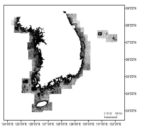
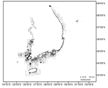
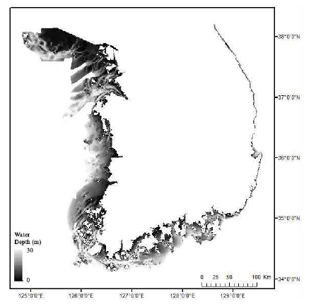
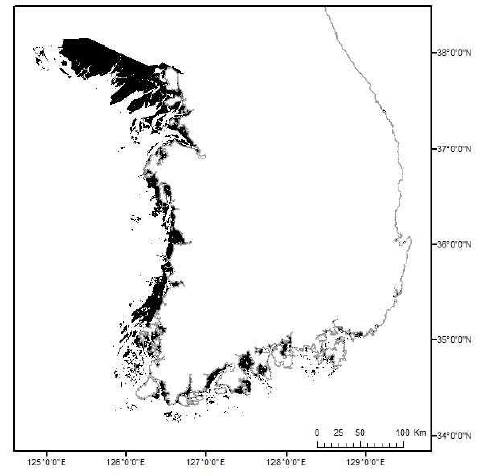
The ENC manufactured by the standards of the International Hydrographic Organization(IHO, 2000) and includes location information such as water depth, sediment type, buildings, structures, buoys, rivers, and roads. The ENC separates levels according to spatial resolution, and the water depth and sediment type data of level 4, which is the highest resolution(scale 1:30,000-1:90,000), were used in this study. Fig. 1 and 2 show that the entire area of the used ENC includes the Korean Peninsula and annexed the island, ranging from longitude 124°15'36''-132°08'24'' E and latitude 32°54'36''-38°50'24''N on coordinate. Fig. 1 shows the merging results of the water depth for the collected ENC. Water depths in some coastal waters exhibit a dense distribution due to merging process of the ENC. Fig. 2 shows the sediment distribution from multiple ENC. It can be seen that the range or density of data is very insufficient compared to the water depth. Especially in the East Sea, data exist only in areas very close to the shoreline. In addition, there is no sediment data in the Mid-Yellow Sea region.
3.2 High resolution water depth and sediment
For the complex Korean coastal waters, the understanding of high-precision maritime environmental information is an essential element for generating optimal ship escape support information. Currently, available ENC provides information with excellent accuracy, but more high-resolution DB is needed to build to provide optimal escape support information in coastal waters. The KHOA regularly conducts high-precision measurement projects on selected areas and limitedly provides high-resolution water depth and sediment measurement data.
The KHOA is acquiring high-resolution water depth data by using a multi-beam echo sounder loaded on survey ships for coastal waters. Due to the limited access like security, the coordinates, and the water depth at the location provided after conducting a security examination on Mokpo, Jeju, Goheung, Wando, Geomundo, and some areas in the West Sea where many passenger ships operated. All the collected coordinates and water depth information was converted to a point-format shapefile using the ArcGIS program. Fig. 3 shows the high-resolution depth data collected by the KHOA observations. Compared to Fig. 1, it can be seen that the water depths of the South Sea area and north of Jeju Island densely distributed.
Fig. 3
Distribution map of the high resolution water depth(Mokpo, Jeju, Goheung, Wando, Geomundo, and some areas of the West Sea)

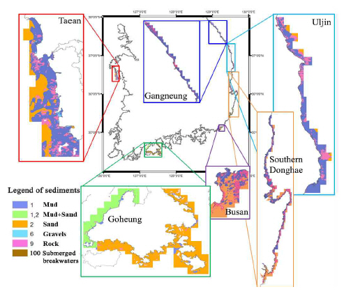
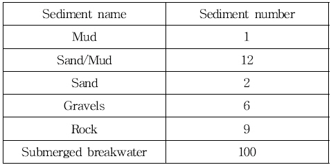
The KHOA collected sediment information in coastal waters through the air hyperspectral sensor(CASI-1500), diving, sample investigation, and ground-spectrum methods. In this study, based on 2018, Jumunjin-Imwon port(128°49' 48''-129°22'12'' E, 37°12'00''-37°54'36'' N), Uljin(129°20'24''- 129°30'36'' E, 36°39'00''-37°12'00'' N), Donghaesi-Busan port(129°20'24''-129°35'24'' E, 35°24'00''-36°39'00'' N), Busan (129°06'00''-129°10'48'' E, 35°04'48''-35°09'36'' N), Taean (126°15'36''-126°22'12'' E, 36°22'48''-36°40'12'' N), Goheung (127°06'00''-127°33'00'' E, 34°24'00''-34°43'48'' N), the sediment type of these six areas was collected. The sediment type classified into six categories, including pearl, pearl and sand mix, sand, gravel, rock, and submerged dike. Then we provided a shapefile of polygon properties. Also, in order to make areas distinction easier, we sorted layers and assigned colors differently by sediment. Fig. 4 shows the sediment type for six regions collected through observations. In particular, the sediment in Taean area was not included in ENC.
3.3 Spatial data of marine managed areas
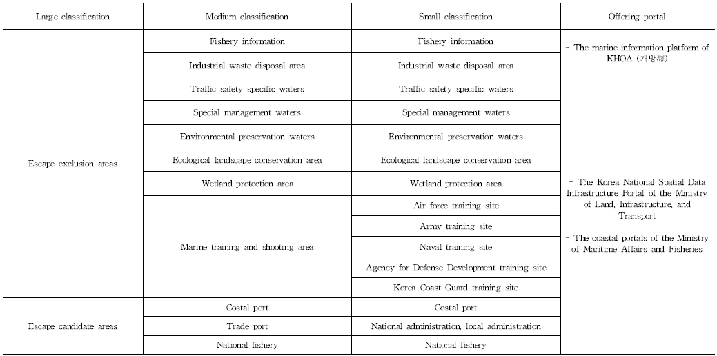
The Marine Managed Areas(MMAs) means a specific zone designated or controlled by the government for pollution, risk management, conservation of resources (Orbach and Karrer, 2010). The MMAs classified into particular management areas for marine pollution, marine training areas for marine risk, environment preservation area for resource, and farm preservation according to the purpose. Table 1 shows that the marine information platform of KHOA(www.khoa.go.kr/oceanmap), the Korea National Spatial Data Infrastructure Portal of the Ministry of Land, Infrastructure, and Transport(http://data.nsdi.go.kr/dataset), and the coastal portals of the Ministry of Maritime Affairs and Fisheries(http://coast.mof.go.kr) used for collecting spatial information of MMAs.
4. Results of database construction
In this study, the DB of water depth, sediment, and MMAs spatial information, which is the considerations in the calculation of candidate groups for ship escape in coastal waters, was constructed. The scope of the water depth DB construction is to set up the seas with water depth more than 0m and less than 30m, using the ENC and high-resolution measurement information and make a grid to a resolution of 50m. To construct the sediment DB, we used a water depth DB construction grid with a 50m resolution. The sediment of each grid was the input of the nearest information from the ENC and measured sediment information. Then, if there is no sediment information within 1 km of the grid center, it is set to blank. The MMAs spatial information was converted to the format of shapefile using ArcGIS.
4.1 Database of high resolution water depth using electronic navigational chart and measurement data
The ENC water depth has a low resolution but covers a large area. On the other hand, surveyed depths have very high resolution, but only in some areas. Besides, both data indicate the depth of the nonuniform grid. The purpose of this study is to construct a DB used to select a place of refuge for ships, and a grid of high-resolution data is efficient for operation and management. Also, the suitability of data capacity must be considered since it involves the purpose of providing real-time information.
In this study, in order to improve the accuracy of the designation of the ship refuge place, we separately constructed a DB of high-resolution depth for the coastal area where ship accidents occur frequently. The coastal waters are assumed to be 0-30m depths around the Korean peninsula. The spatial resolution of the depth of the coastal waters DB set at 50m, and the ENC and the KHOA data used. In the region where the two data overlap, data processing is performed to remove the ENC data. The data of the adjacent location in the surveyed water depth classified into the same object and the polygon generated, and the electronic chart water depth data included in the polygon removed. Fig. 5 shows that the remaining depths after the removal of the ENC and the surveyed depths were merged to create high-resolution depth DB. Compared with Fig. 1, it can be seen that the depth data of the south-west sea and the north sea of Jeju have changed.

ArcGIS Inverse Distance Weighted(IDW) Toolbox was used to generate 50m grid information. The IDW based on the assumption that the relevance and similarity between the values of a particular position and a surrounding position are inversely proportional to distance(Setianto and Triandini, 2013). In order to input the IDW, the depth data converted into the UTM coordinate system, and the number of neighborhoods included in the influence range for a selected point set to 15. Fig. 6 shows that the raster file produced using IDWwas separated using a polygon file of a 0-30m depth area. The separated raster file was saved as the shapefile of the point attribute and entered into the DB.
4.2 Database of sediment data in coastal waters
This section described the process of integrating the sediment of ENC and measured data. First of all, because the notation of the ENC and the measured data are different, we made it uniform using the notation name and number of the electronic chart, as shown in Table 2. In the electronic chart, because there is no number assigned, 'Submerged breakwater' is numbered as 100 in the DB. In generally, submerged breakwaters are not included in the sediment classification, but included because they affect the safety of ship navigation. In order to increase the calculation efficiency when calculating the ship support information, the grid of the integrated sediment and the depth information is set to be the same. The merged sediment information was generated by inputting in the same grid with the ENC and the measured location information. Furthermore, the sediment information at the 'NaN' grid generated by the spatial interpolation method with the 'Nearest' option. Fig. 7 shows the re-sampled sediment data in coastal water.
4.3 Database of special data of marine managed areas
In order to select a refuge place of ship, it is necessary to set the area where escape is impossible to prevent secondary damage. On the other hand, information about the surrounding ports is needed to restore the vessel's and reduce the risk of navigation, and it may be considered a refuge place. Therefore, in this study, it was classified into a non-escape and escape candidate area considering the characteristics of MMAs, as shown in Table 1. The non-escape areas include fishing zones, environmental protection waters, military training waters, etc., and the escape candidate areas include port information. The spatial information classified into layers according to the classification criteria and the shapefile of the polygon attributes generated by using ArcGIS. Fig. 8 shows the classification result considering the characteristics of MMAs.

4.4 Utilization of database
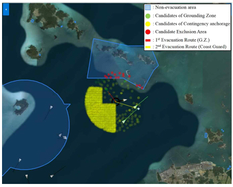
The built database can be used to extract a suitable place for the ship to stay in an emergency situation. We collected the AIS information of the collision accident between the Oriental Pearl II and the PILION ship at 06:28 on 05 January 2011 and defined it as an incident corresponding to escape level 1 by ‘crash’ regarding the contents of the written judgment. The navigation environment parameters included in a regular radius around the location of the target vessel was extracted and is used to calculate the candidate of grounding zone, contingency anchorage and exclusion area, respectively.
Fig. 9 is the output screen of the results of the calculation of the grounding zone, contingency anchorage, and the candidate exclusion area. The green and yellow circles indicate the possible location of the grounding zone and contingency anchorage, respectively. The blue polygon indicates the escape exclusion zone. If a candidate area for the grounding zone or contingency anchorage included in the escape exclusion zone, it will be changed to red and be output to the candidate exclusion areas. When the ship's location is changed, the information contained in the radius is automatically changed and updated. Then, the extracted navigation environment parameters used as input data to the escape route selection algorithm proposed in Park et al.(2018). This algorithm estimates the most suitable evacuation site considering the ship's condition and surrounding environmental factors. In the situation in Fig. 9, the grounding zone was guided to the excellent contingency place(red line), and the surrounding coast guard ship guided to the second contingency(yellow line).
5. Conclusion
In this study, the navigational environment parameters for coastal waters were constructed using the ENC, measurement data, and geographic information. Then, it was used as the supplementary data to find contingency places in an emergency ship. For the water depth and sediment data, the ENC and high-resolution data provided by the KHOA used. In the case of ENC, its data exists in most areas of the Korea Peninsular, but is less accurate due to low resolution. To compensate for this, we collected high-resolution data, although data exists only in some areas.
The geographic information on ports, fish farms, and unique waters in the coastal waters of the Korean Peninsula established into DB in the form of a polygon-type shapefile. The data obtained from the KHOA's portal ‘개방海’, the coastal portal of the Ministry of Maritime Affairs and Fisheries and Korea National Spatial Data Portal of the Ministry of Land, Infrastructure, and Transport. All data were converted into shapefiles using the ArcGIS program or organized by sorting out the layers. Using the navigation environment database, we applied it to an algorithm that automatically extracts the intentional grounding zone and contingency anchorages in the ship emergency.
For high-resolution water depths and sediments, data collection was performed only for those areas that surveyed and available for the release of information. In the case of MMAs, only the data registered in the information portal used. In particular, it estimated that there are many unregistered artificial structures, such as fisheries and buoys. If these structures are detected by remote sensing technology in the future, more accurate marine obstacles can be added. Although data collection limits exist, it expected that the established DB through this research would be usefully utilized for extracting the contingency place of the ship in an emergency.
 PDF Links
 PubReader
 Full text via DOI
 Download Citation
 Print
Print


