A Study on Implementation of Safety Navigation Mobile Application Converging Marine Environment Information and Location-Based Service
Article information
Abstract
In this paper, we implemented a safety navigation mobile application that converged AtoN information and location-based services. When application user uses the smartphone’s GPS sensor to transmit the user’s vessel location data to the data server, the user receives information of which its providing range is considered, such as stored AtoN data, neighboring vessels information, danger area, and weather information in the server. Providing information is sorted based on the smartphone’s direction and inclination and it will be also delivered via wireless network (5G, LTE, 3G, WiFi). Additionally the application is available to implement other functions such as information provision through voice and text alarming service when the user’s vessel is either approaching or entering the danger area, and an expanded information provision service that is available in shadow area linking with data-storing methods; other linkable data such as weather and other neighboring vessels will be applied based on the lasted-saved data perceived from the non-shadow area.
1. Introduction
Mobile platforms prior to smartphones were in the form of older feature phones that only exchanged voice calls or text messages. However, with the advent of smartphones, the paradigm of the mobile platform has changed dramatically. In addition to the functions of the previous feature phones, which only send and receive voice calls or text messages, smartphones use various sensors of smartphones to create applications that users need and upload them to the mobile platform. But other users who need it can also download and use it on mobile platforms(Jeong, 2010; The Korean Institute of Communications and Information Sciences, 2009). In addition, since the mobile platform can communicate not only with smartphones but also with things that can be seen around us, such as the Internet of Things(IoT) and the Internet of Everything(IoE), researches are progressing to actualize the introduction and implementation of the IoT. In addition, technologies such as Argument Reality(AR) and Virtual Reality(VR) have emerged, and researches for solving safe navigation using these technologies have been conducted in various ways(Kim, 2015; Kim, 2017).
The fishery information alert, which is currently operated by Suhyup, has an information mobile service in the field of fishermen's safety to be used for the fishery safety information service through an immediate telephone connection service and a push message in case of an emergency(National Federation of Fisheries Cooperatives, 2015).
In this paper, two main goals were proceeded: accepting the needs of 4th industrial society, solving safe navigation. In other words, this paper proposes solution to solve the social problem of collision of small ships that are not equipped with AIS(Automatic Identification System) and VHF-DSC system that informs the position of ships based on reflecting the demands of the current era of radical changes in the IT society(Choi, 2013; Lim, 2012). In addition, this application is intended to be implemented in navigational safety mobile application that combines more realistic and efficient AtoN(Aids to Navigation) information and location-based services by utilizing server and client communication and smartphone sensor and GPS technology.
2. Mobile Application
Mobile Application is expanding rapidly due to the development of smart devices such as smartphones and tablets, and the expansions of wireless Internet supplies. Among the sensors mounted in smart devices, cameras, data communication, GPS sensors, tilt sensors, and digital compasses, which can be applied to mobile applications, are starting to be installed, enabling maritime information mobile services. Location-based mobile service, which are being actively researched in recent years, mostly use technology based on sensor-based tracking(Kim, 2013; Song, 2012).
2.1 Location-based Mobile Application
The main technologies required for the implementation of location-based mobile application are tracking technology for the user's position, direction, and movement, registration technology which creates virtual object through computer graphic and accurately place the object on the actual image location, and User Interface technology which handles interaction with the user, such as display, etc(Kim, 2009).
For mobile application, as shown in the Figure 1, the AtoN location and danger area, which are perceived by GSP module from rendering module, will be displayed with notification mark through merging module transferred from DB server. Those perceived data will be displayed if the user transmits display area of ENC(Electronic Navigational Chart) and others measured by the tilt of smartphones and orientation sensors.

Location-based service configuration
2.2 Navigation Safety Information Scenario
The scenarios that can generate data using various sensor technologies such as GPS, tilt sensor, and orientation sensor installed on smartphones, and receive accurate information about the user's surrounding environment and navigation safety information are shown in Table 1.

Navigation safety information scenario
3. Application that combines marine environment information and location-based services
3.1 Application
As shown in Figure 2, users can search the AtoN, navigation history, weather forecasts, and dangerous areas by using data server via wireless communication network (5G, LTE, 3G, Wifi). In addition, users can quickly and easily process maintenance and management tasks by registering the presence or absence of the AtoN failure in the application as real-time.
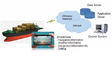
The system configuration that is based on the location
It is possible to promote the safety of ship operation by providing information to users by checking the location and ship type of surrounding small ships without AIS in real time.
Figure 3(a) shows the user's desired area by calculating the user's location information using GPS, the left and right width using the digital compass, and the distance using the tilt sensor. It is possible to express data for providing and managing AtoN information within its area. In Figure 3(b), when the ship's rowing and pitching is so severe that the sensor of the smartphone cannot be used, the distance and direction can be manually manipulated.
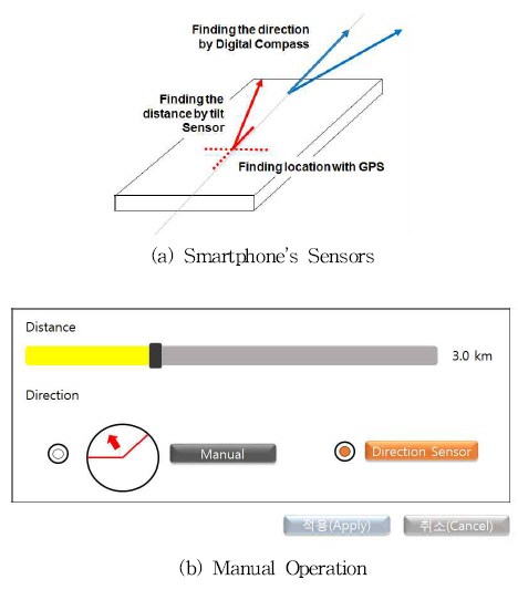
Desired area settings using Smartphone’s sensors, manual operation
3.2 System Modeling
1) System Configuration
Figure 4 shows the system diagram of ‘BadaGO’, the implemented application. The BadaGO application consists of four components. The first component is a database adapter component that requests or reports AtoN information and dangerous area information, user’s report information from the server's database. The second is an S-ENC viewer component converts the data of the ENC(electronic navigational chart) to S-ENC and outputs it to the screen. The Third is a weather adapter component that requests information of weather forecast and weather bouy through the Meteorological Agency API. The last is an UI component that displays received information on the screen, and information are from the database component, the ENC viewer component, and the weather adapter component on the screen.

An implemented system configuration for BadaGO application
Figure 5 shows the software structure according to the system configuration. It consists of a server that stores DB, an application server that loads DB, and a mobile client. The mobile client is configured to call the Meteorological Agency API to receive weather data and display sea information on the screen.

Software architecture of BadaGO application
2) Database Modeling
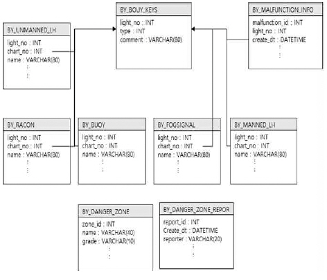
Figure 6 shows the modeling among databases. It consists of nine database tables that includes the buoy keys tables, unmanned lighthouse data tables, racon data tables, manned lighthouse data tables, buoy data tables, fog signal data tables, fault reporting data tables(Malfunction_Info), danger zone data tables and danger zone report data tables. Of these, the buoy keys tables contain information about the numbers and types of all the AtoN. Therefore, the AtoN data corresponding to the AtoN numbers in the buoy keys tables are searched for.
Database modeling
Figure 7 shows the database development screen of established database tables using HeidiSQL, an open source client.

Development screen of database
4. Results
4.1 Mobile Electronic Navigational Chart
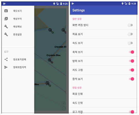
The electronic navigational chart converts the electronic chart(S-57) data to S-ENC in the SENC module. The converted data is converted into an electronic chart through the SENC Viewer and displayed on the smartphone screen by applying the visualization settings set by the user through the UI module. The setting screen of Electronic chart is shown in Figure 8.
Setting screen of Electronic chart
4.2 Aids to Navigation
The AtoN details shown in Figure 9 are identified by the number of AtoN selected by the user in the buoy keys tables, which are built into the system database in the database adapter. The detailed AtoN information is displayed on the user's smartphone screen through the UI module.

Detailed information of aid to navigation
4.3 Weather forecast
Figure 10 shows the screen displayed on the user's smartphone after receiving the weather information from the meteorological buoy. The maritime meteorological information displays marine meteorological information supplied from the meteorological buoy, etc. on the user's smartphone screen through XML parsing in the UI module.
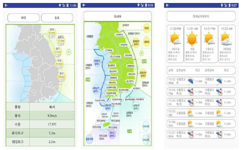
Weather forecast for sea area
4.4 Safety Navigation
Maritime safety navigation information delivers navigation dangerous area information adjacent to the current position in the danger zone data tables built in the system database in the database adapter. The navigation dangerous area information is displayed on the electronic chart through the UI module and displayed on the user's smartphone screen. Figure 11 shows the dangerous area display, the dangerous area information is displayed by the electronic chart and user report.

Danger zone for navigation
Figure 12 shows the marine safety navigation information from the database adapter that retrieves the navigation dangerous area information adjacent to the current location from the danger zone data tables built in the system database. Navigation dangerous area information is displayed on the electronic chart through the UI module to be displayed on the user's smartphone screen and guided to the user by voice.
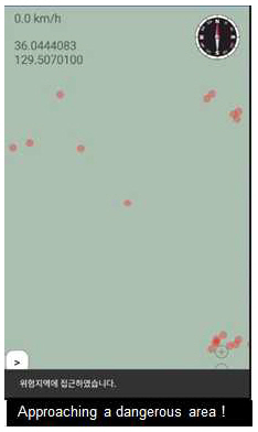
Notification and voice message for dangerous area
4.5 Dangerous Area and AtoN Disorder Report
Navigation of dangerous areas is reported directly by the user who navigates the danger area. When the risk information is reported through the application, the report on the dangerous area is updated by performing a system adapter through the database adapter. The administrator checks the updated contents and updates the navigation danger zone database so that the reported dangerous area can be guided to the user. The user's location is automatically updated in the database using the GPS module of the smartphone rather than being created by the reporter.
Figure 13 shows the navigational dangerous area reporting screen the user has provided to the user's smartphone to report the navigational dangerous area.
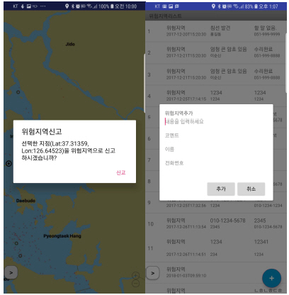
Report dangerous areas
In the case of disability report, the user directly reports the disability of the AtoN. When the failure details are reported through the application, the AtoN failure report details are updated in the system database through the database adapter. When the administrator checks the updated contents, the administrator takes action on the fault history and updates the history of the failure in the system database.
Figure 14 shows the screen of the AtoN failure report screen that the user provided to the user's smartphone to report the AtoN failure history.
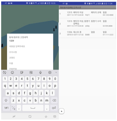
Report failure of aid to navigation
5. Conclusion
In order to implement ships to navigate safely, it is important to receive the condition of the route through the AIS. Even Ships without AIS also require information, including the ship's dimensions, type, location, route status and other safety information. Therefore, Badago application can be easily provided with all the information necessary for navigation using a smartphone.
Some components of BadaGO, a safe-navigation information providing service for navigators and ordinary people who sail on small vessels, are implemented in a form that can be applied as augmented reality components or UI components. Not only the location, history management, and status information on the AtoN facilities can be managed in real time using a smartphone, but also failures, losses and damages can be responded quickly.
