J Navig Port Res > Volume 46(5); 2022 > Article
Park, Jeong, and Yoo: Analysis of Requirements for New Aids-to-Navigation Service - Focusing on Ship Operator

ABSTRACT

With digitalization accelerated by the 4th industrial revolution, the marine traffic environment is also expected to change rapidly. The purpose of this study was to derive a new service for Aids to Navigation (AtoN) to respond to a new marine traffic environment and suggest service requirements from the perspective of the ship’s operator. For this purpose, a survey of ship operators was conducted and IPA analysis was performed. Marine traffic intelligence and information services and Image-based ocean environment information services were deduced as high-priority services from the perspective of ship operators. Thus, the derived results can serve as basic data for developing new AtoN services and determining policy directions.

1. Introduction

Aids to navigation (AtoN) means a device, system or service, external to vessel, designed and operated to enhance safe and efficient navigation of individual vessel and/or vessel traffic(IALA, 2016). The marine traffic environment is undergoing rapid changes owing to technological developments such as maritime autonomous surface ships (MASSs) and smart ports, in parallel with the advent of the fourth industrial revolution. International Maritime Organization (IMO) is implementing work to form a regulatory framework for emerging MASSs, and aims to complete the development of non-forced regulations by 2025(IMO, 2022). International Association of marine aids to navigation and Lighthouse Authorities (IALA) is also discussing support facilities for accommodating MASSs. Meanwhile, the Republic of Korea is carrying out MASSs technology development project led by the government, and aims to complete it by 2025(MOF, 2020). Furthermore, the government is expected to accelerate the digitalization of maritime areas in the future by presenting optimized smart maritime logistics concepts through logistics information between operating entities and facility operation linkage based on automation and intelligent ports and ships.
Therefore, to facilitate changes to the marine traffic environment and secure maritime safety, the existing AtoN service should be improved, and integrated information services are to be provided. In particular, various information generated via AtoN requires integrated management, and because those information be processed into secondary data through analysis, an integrated information system that can manage them and provide new services is required.
Meanwhile, the Republic of Korean government aims to introduce the concept of Smart Aids to Navigation (Smart AtoN), develop new AtoN services, and develop a system that can manage new services as their “Master Plan(3rd Maritime Safety Master Plan)(MOF, 2022).”
There were many studies related to AtoN on the development of a model related to cost, such as the calculation of AtoN usage fees(Moon et al., 2020), estimation of navigation risk costs(Kim and Moon, 2018), estimation of social costs(Moon and Kim, 2019), and utility analysis models(Park and Gug, 2016). Also, from the perspective of AtoN users, there were studies on simulation education, and from the perspective of AtoN managers(Jeong et al., 2019), research on software development for AtoN management and deployment decision-making, etc., using simulation technology related to AtoN to improve service quality(Kim et al., 2014). Until now, study on AtoN has been focused on the operation and management of current AtoN, and study on new traffic environments is difficult to find. There was a study on the design and development of the standard for the AtoN management and operation system for the new maritime traffic environment(Yeo and Jeong, 2021), but this was a study on the AtoN management and not from the perspective of the ship operator using the actual AtoN. This study has a differentiation in evaluating the requirements for the new function of the AtoN for ship operators who are subject to service using the AtoN.
The purpose of this study is to analyze the requirements of users to secure the effectiveness of the new AtoN service for future maritime traffic management. In this regard, the relevant policy of the Korean government and relevant trends from the IALA were reviewed. Furthermore, by introducing Smart AtoN services ready for the future and conducting interviews with marine users and AtoN operators who would be the target users, requirements for new AtoN services were derived. Subsequently, based on the requirements derived from the interviews, a questionnaire was prepared to conduct an online survey.

2. Current Status of Policy Pertaining to Aids-to-Navigation

2.1 Republic of Korea

The Master Plan for AtoN is established in accordance with Article 6 of the AtoN Act, and the plan for the 5th year after the establishment and implementation of the Master Plan. A feasibility study was conducted for the Master Plan to present a “Revised Master Plan.” The Revised Master Plan was established based on performance analysis, changes in marine traffic environment, and research and analysis pertaining to AtoN-related international trend. The Revised Master Plan established in September 2021 included the proposal of new policy projects such as the development of high-precision navigation and Smart AtoN technology, which is consistent with the implementation of sea navigation (e-Nav) and the introduction of the MASS and smart ports. Additionally, for the AtoN policy, to accommodate the expansion and advancement of the AtoN infrastructure, the revised plan includes infrastructure-linked services. Through the Master Plan for AtoN, the vision of “establishing a safe sea environment” was presented and four specific targets were specified. The targets are to expand the AtoN to one per 2.4 miles of coastline, achieve a AtoN service operation rate of 99.6%, introduce a high-precision PNT system and smart AtoN, preserve and utilize lighthouse marine culture, and strengthen international cooperation(MOF, 2021a master plan). In particular, through the introduction of smart AtoN, it plans to convert AtoN from analog systems to digital-based intelligence systems in preparation for changes in the maritime environment. In addition, it plans to develop customized services such as systematic management of AtoN and marine disaster services(MOF, 2021b). In other words, the direction of Korea’s AtoN policy can be seen as preparation of AtoN to prepare for new maritime traffic.

2.2 IALA

IALA is establishing mid-to long-term development directions and strategies to respond to rapid technological developments and environmental changes such as digitalization, hyperconnectivity, big data, and cybersecurity. IALA’s strategy was approved by the General Assembly in May 2018. The aim of IALA is to foster the safe, economic and efficient movement of vessels, through improvement and harmonisation of aids to navigation worldwide and other appropriate means, for the benefit of the maritime community and the protection of the environment(IALA, 2018).
The IALA strategy consists of 2 goals and 8 strategies. Strategies 3 and 5 are related to future AtoN as follows.
Strategy 3 - S3 - Coordinate the further development of Marine Aids to Navigation, taking into account evolving operational and functional requirements, new techniques, new technologies and sustainability.
Strategy 5 - S5 - Harmonise the information structure and communications for future navigation by creating standards, and by cooperation with other international organisations, to achieve worldwide interoperability of shore and ship systems. Based on the strategy, IALA is expected to expand the role of future-oriented AtoN.

3. Survey of Requirements

3.1 New Smart AtoN Service

Kim (2019) suggested a new role by combining information digitization of AtoN, standardization of information exchange system, diversification, integrated DB construction, and cutting-edge ICT technology. Its roles include collection and sharing of AtoN image information and monitoring of changes in marine ecosystems. In addition, services for small fishing vessels, services for MASSs, and air quality services using AtoN were proposed as new services using existing AtoN(Kim et al., 2021; Moon et al., 2021; Choi et al., 2021a; Choi et al., 2021b; Oh et al., 2021). Table 1 is a table showing an overview of the new service of the AtoN and the target of the service.

3.2 Online Survey

To identify the requirements for the Smart AtoN service for the operators of a seagoing ship and the general public, we conducted an online survey. The online survey was conducted for 12 days from November 8, 2021 (Mon) to November 20, 2021 (Sat). The importance, urgency, and requirements for services were investigated for the services presented through previous studies. To assess the importance and urgency, a five-point Likert scale was used, and requirements were derived based on multiple-choice and subjective-type questions. A total of 103 people from the maritime sector were surveyed. The participants of the survey included experts from relevant field in industry, universities, research institutes, and governments such as the Ministry of Oceans and Fisheries and the Korea Coast Guard.

3.3 Analysis Methodology

Importance-satisfaction analysis is a method proposed by Martilla and James(1977). It is a model that can simply suggest which aspects a company should pay attention to when establishing a marketing strategy for improving customer satisfaction. However, the importance and satisfaction of the respondents should be independent of each other during the survey, but in reality, the survey results showed a lot of linear results, which pointed out a problem. Therefore, a modified IPA technique has been proposed to improve this(Deng, 2007). Deng(2007) derived the partial correlation coefficient through analysis of the satisfaction value and partial correlation by taking the natural logarithm of the satisfaction level for each attribute directly entered by the respondent. And the derived partial correlation coefficient uses the relative importance value of each item. In this study, as a requirement for future technology, urgency was applied instead of satisfaction(Go and Kim, 2021).

4. Requirements for the new service of AtoN

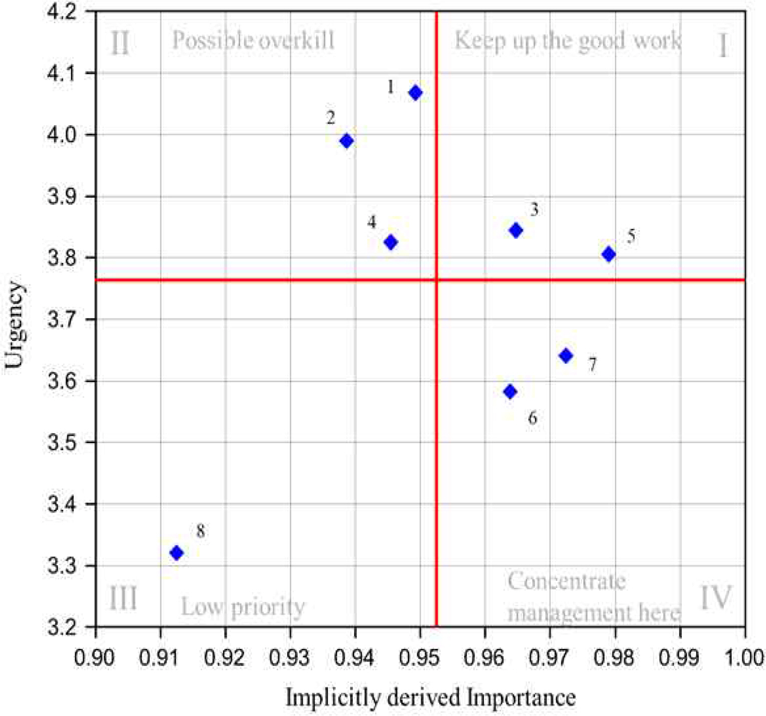
4.1 Results using the modified IPA

Fig. 1 is a figure showing the results using the modified IPA. Through the IPA analysis, the target strategy can be established. The first quadrant is important, and as an urgent alternative, it is necessary to continuously pursue the current strategy. The maritime traffic intelligence & information service (3) and the image-based marine environment information service (5) were derived as the most important and urgent services of AtoN from the perspective of the ship operator. Standardization of information necessary for navigation and image information are strategies that have a direct impact from the navigator’s point of view, and are judged to have high priority. The second quadrant is an urgent alternative, although its importance is rather low, and should be introduced as a future introduction strategy while avoiding excessive efforts in the future. Small fishing vessels navigation safety index (1), Oceanroad app integration service (2), and S-200-based AtoN information service (4) were derived as urgent services although their importance was somewhat low. The small fishing vessels navigation safety index and OceanRoad App integration service are not directly related to navigation, and the AtoN information of the S-200 is related to navigation, but it is judged that the AtoN is not an important factor. In the third quadrant, both importance and urgency are evaluated as low and are considered low-priority services. Since the service that measures air quality using a AtoN is not directly related to navigation, it is judged to have the lowest priority from the navigator’s point of view. The forth quadrant is an alternative that is of high importance but not urgent, and requires an intensive management strategy. Although the importance of MASSs and marine environment-related services is acknowledged, it does not directly affect the current navigator. In particular, the urgency of autonomous ships is low because the legal framework is currently under discussion, and commercialization is in the future.

4.2 Service-specific requirements

Materiality In addition to the urgency survey, the preferred provision type, frequency, and new service requirements from the perspective of ship operators were surveyed for each service.
  1. 1) Navigation safety index for small fishing vessels

    In terms of the type of service delivery, analysis shows that the participants preferred e-Nav system (66%) and an integrated management system for ensuring fishing boat safety (49.5%). In addition to coastal and offshore fishing boats, the analysis shows that index service was required for agencies that can manage fishing boats, such as the Korea Coast Guard (Naval ships and vessel traffic services (VTSs)) and the Ministry of Oceans and Fisheries (control center). As for the period of service delivery, most participants indicated preference for the 1-hour period. The following were derived with regard to the service delivery.
    • - Improved service can be expected if the surrounding marine traffic environment, such as the vessel traffic volume and vessel density in adjacent areas, can be considered in the service.

    • - The service can be utilized more practically when information such as the tonnage and maneuverability of the target vessel is reflected and applied to sea weather conditions.

    • - In terms of sea weather, visibility is the most important factor, and when possible, tides should be considered.

  2. 2) OceanRoad App Integration Service

    Among the participants surveyed, 40 (38.8%) were experienced in using the OceanRoad application, and 25 (56.8%) expressed satisfaction with the OceanRoad application service. Among the services to be provided via OceanRoad App, the respondents showed the highest preference for the navigation safety index for small fishing vessels service, followed by the virtual AtoN service and marine environment information service. As for the additionally required services for OceanRoad App, the proposed ideas included triggering an alarm when a ship enters a hazardous zone or when the navigation route of the ship included the VTS zone. The following considerations were derived for the OceanRoad app service delivery:
    • - Orientation and distance from the ship in accidents involving casualties.

    • - Display of all data on an electronic navigational chart is not necessary considering readability issues; however, navigation information such as hazardous zones should be updated in real time.

    • - Consideration of the communication environment. Communication in the ocean environment remains insufficient.

    • - Necessity for improving the response rate.

    • - Requirement for a function that allows a free setting, such as the location information record update cycle.

    • - Data extraction where possible.

    • - Simplification of the service presentation using an intuitive UI(User Interface) and placement of key functions (emergency rescue requests, etc.) in prominent spots.

    • - To facilitate search and rescue, the projected points of drift should be specified based on weather conditions, such as ocean currents.

    • - More functions should be made available to non-marine workers.

    • - Development of a “report system with displays” to directly and immediately display the screen of the video captured by the person who reports an incident.

  3. 3) Marine traffic intelligence and information service

    The survey participants referred to various nautical publications for ship navigation or marine traffic management; they used sailing directions the most, followed by tide tables, tidal current charts, and chart symbols and abbreviations. Among the participants, 89.3% responded that the integration of information such as notices and sailing directions into the system will provide significant benefits.
    Most of the respondents indicated that electronic data such as e-Nav system and ECDIS were required in terms of the service method.
  4. 4) S-200-based AtoN information service

    The level of satisfaction with the current ECDIS update cycle was moderate. Additional information necessary for the ECDIS were as follows:
    • - Real-time information regarding hazardous objects (automatic display of T&P(Temporary and Preliminary notices) for accident occurrence status, offshore construction status, etc.)

    • - Weather information in sea area.

    • - Automatic update of information received by Navtex.

    • - Current density of ships and fishing vessels.

    • - Weather and area with vessel traffic congestion using the overlay function.

  5. 5) Image-based ocean environment information service

    The analysis showed that significant issues caused by inadequate real-time ocean weather observation information were difficulties in the objective assessment of the weather and delay in preparation for severe weather conditions. Respondents preferred to derive objective values of the marine environment through image analysis.
  6. 6) Safety information service for MASS

    Respondents indicated information regarding adjacent routes, vessel traffic density, and regulations for ship operation in the area. Additional information that can be provided for the MASS using the AtoN are as follows:
    • - Safety distance to the AtoN (e.g., trigger an alarm when a certain distance is approached).

    • - Field sight of the remote operator through a CCTV.

    • - Abnormal object detection using images.

    • - Current status of vessel traffic density in adjacent waters.

    • - Information regarding restricted waters.

    • - Continuous provision of reliable position information.

  7. 7) Marine environment information service

    In terms of issues pertaining to the currently provided marine environment information, limitation regarding spatial information constituted the highest proportion, and the provision of raw data without data analysis was indicated as well. The highest percentage of the survey participants responded that the preferred update cycle for receiving reliable information from the AtoN was 10 minutes.
  8. 8) Port(marine) air-quality service

    As for the pollutants that required measurements in an ocean environment, NOx constituted the highest percentage, followed by SO2 and CO. In terms of the air-quality service, air-quality statistics in the port area constituted the highest percentage in terms of necessity, and the comparison of air quality in terrestrial and marine environments was proposed. Additional responses from the participants regarding the air-quality measurement service using the AtoN are as follows:
    • - Continuous soot emission from funnels occurred during sailing; hence, air-quality statistics for the ocean environment are required and should be made available to the general public.

    • - To improve the reliability of the measurement, the measurements should be segmented by each sea area

    • - Research pertaining to emissions using ship information has been actively pursued. Particulate matter information measured using the AtoN is expected to increase the accuracy of emission information.

    • - Air-quality service is expected to be utilized as a major indicator for monitoring and imposing restrictions on ships in adjacent seas.

    • - Priority installation is required around the area of berths in a port.

Conclusion

In the maritime sector, digitalization has progressed rapidly owing to the advent of the fourth industrial revolution. Accordingly, the marine traffic environment is expected to undergo significant changes. In this regard, AtoN, a marine navigation aid equipment, should be able to offer adequate services. According to the government policy, information obtained from the AtoN will be processed as big data and provided as new service to users. The purpose of this study was to analyze user requirements for the new AtoN service, and the following were performed:
  • - Current status of AtoN-related policy

  • - Identification of user requirements via an online survey of personnel in AtoN-related industries by presenting items identified through a preliminary AtoN user interview

As a result of the survey, from the perspective of the ship operator, the service directly related to navigation was the most preferred, and the service using the basic information that can be collected from the AtoN is the most important and urgent. Among the requirements for services, the needs of providing digitalized services were identified. In other words, the reliability of the service is important, but it is judged that the service provision method is also important. Although this study is meaningful in quantitatively presenting priorities using the IPA methodology, it is difficult to quantify detailed requirements. Therefore, it is judged that in-depth interviews with experts are necessary in the future.
In this study, the opinions and requirements presented from users for the development of a new AtoN service were analyzed comprehensively. However, because the AtoN forms an infrastructure used by ships for international navigation as well as domestic vessels, the contents investigated in this study should be disseminated to the international community, such as the IALA, and further supplemented in the future. In addition, system requirements should be analyzed to establish a new marine traffic environment using the new service.

Acknowledgments

This research was a part of the project titled ‘Marine digital AtoN information management and service system development(2/5) (20210650)’, funded by the Ministry of Oceans and Fisheries, Korea.

Fig. 1.
The results using the modified IPA
KINPR-2022-46-5-392f1.jpg
Table 1.
New service of the AtoN and the target of the service
No. Name of Service Definition and Products Target
1 Navigation safety index for small fishing vessels Definition A service that provides a navigation safety index for offshore and coastal fishing vessels (not exceeding 30 tons) using real-time ocean weather information (wave height, wind, and visibility) acquired by AtoN. Ship operator
Products (Special alert/normal) Provides navigation safety index by sea area/tonnage
2 OceanRoad app Integration Service Definition An integrated marine information service that can be provided by adding to the chart through the OceanRoad App Ship operator, General public
Products Various information of AtoN services (navigation safety index for small fishing vessels, virtual AtoN, ocean environment information, visual presentation of weather conditions, etc.) is provided through OceanRoad App
3 Marine traffic intelligence and information service Definition A service that provides marine traffic intelligence and information to utilize AtoN service and support MASSs Ship operator
Products Situation-specific information such as notices and navigation guideline is provided in the form of S-200 standard data
4 S-200-based AtoN information service Definition AtoN management information and information acquired from information cooperation center is provided based on S-200 and service standards Ship operator
Products Basic AtoN information, changes in information and AtoN information other than emergency information is provided.
5 Image-based ocean environment information service Definition Ocean environment information (length, height, and period of waves) using image information is presented in the service. Ship operator
Products Information regarding length, height, and period of waves based on CCTV image analysis is provided.
6 Safety information service for maritime autonomous surface ship Definition A service that provides safety information to support safe sailing of MASSs Operators related to MASS
Products Provision of information regarding wave direction, wave height, tide height, flow direction, and flow velocity
7 Marine environment information service Definition A service that provides uniform marine environment information for each region Ship operator, General public
Products Real-time information of marine environment (temperature, humidity, atmospheric pressure, wind direction, wind speed, water temperature, dissolved oxygen, and salinity)
8 Port (marine) air-quality service Definition Service provided to marine users by measuring air quality in ports and coastal areas General public
Products Result of particulate matter measurement

References

1 Choi, KY, Park, YS, Kim, DW and Song, JW(2021), “A study on safety measures for small fishing boats using marine weather signal information”, Proceeding of Journal of Korean Navigation and Port Research, Ulsan, pp. 48-49.
2 Choi, WJ, Moon, SB, Jeong, M, Lee, SG and Song, JW(2021), “A study on the use of marine environment information based on AtoN”, Proceeding of Journal of Korean Navigation and Port Research, Ulsan, pp. 46-47.
3 Deng(2007), “Using a revised importance-performance analysis approach: The case of Taiwanese hot springs tourism”, Tourism Management, Vol. 28, No. 5, pp. 1274-1284.
crossref
4 Go, DH and Kim, JC(2021), “A Study on the Awareness of Applying Blockchain to the Fisheries.” The Journal of Fisheries Business Administration, Vol. 52, No. 1, pp. 65-82.
crossref
5 IALA2016), IALA dictionary 2016revision.
6 IALA2018), Strategic vision for the period 2018-2026.
7 IMO2022), Report of the maritime safety committee on its 105th session.
8 Jeong, WL, Jo, GJ and Moon, SB(2019), “A Study on the Development of Educational Modules for Aids to Navigation Using the Aid to Navigation Simulator”, Journal of Korean Navigation and Port Research, Vol. 43, No. 6, pp. 361-368.
9 Kim, AY, Lee, YJ, Park, SK, Oh, JY and Kim, YG(2014), “A Study on the AtoN Operational Software Development for the AtoN Management and the Decision Support of its Placement Planning”, Journal of The Korean Society of Marine Environment & Safety, Vol. 20, No. 5, pp. 543-551.
crossref
10 Kim, TG and Moon, BS(2018), “Study on Estimating Economic Risk Cost of Aids to Navigation Accident in Busan Port, Korea using Contingent Valuation Method”, Journal of Korean Navigation and Port Research, Vol. 42, No. 6, pp. 478-485.
11 Kim, YJ(2019), “Establishment of smart AtoN and implementation plan”, Proceeding of Journal of Korean Navigation and Port Research, Busan.
12 Kim, YJ, OH, SW, Kang, DW, Choi, HS, Park, SK and Jang, JH(2021), “Information cooperation system design study for digital AtoN information management”, Proceeding of Journal of Korean Navigation and Port Research, Ulsan, pp. 41-43.
13 Martilla, JA and James, JC(1997), “Importance-Performance Analysis.” Journal of Marketing, Vol. 41, No. 1, pp. 77-79.
crossref pdf
14 Ministry of Oceans and Fisheries(2020). Press release; Started Autonomous ship development project, https://www.mof.go.kr/article/ (Assessed in July 2022)..
15 Ministry of Oceans and Fisheries(2021a). 2nd Aids to Navigations Revised Master plan, https://www.mof.go.kr/article/ (Assessed in July 2022)..
16 Ministry of Oceans and Fisheries(2021b). Implementation plan of Aids to Navigation in 2021, https://www.mof.go.kr/article/ (Assessed in July 2022)..
17 Ministry of Oceans and Fisheries(2022). 3rd Maritime Safety Master plan, https://www.mof.go.kr/article/ (Assessed in July 2022)..
18 Moon, BS and Kim, TG(2019), “Study on Development of Social Cost Estimating Model for Aids to Navigation Accident(II)”, Journal of Korean Navigation and Port Research, Vol. 43, No. 3, pp. 166-171.
19 Moon, BS, Jeon, GJ and Kim, TG(2020), “A Study on Estimating the Appropriate Fee of Aids to Navigation Service for the Pyeongtaek Regional Office of Oceans and Fisheries”, Journal of Korean Navigation and Port Research, Vol. 44, No. 4, pp. 347-353.
20 Moon, BS, Song, JW, Kang, JK, Kim, NE and Kim, TK(2021), “A study on location selection of AtoN for air environment measurement”, Proceeding of Journal of Korean Navigation and Port Research, Ulsan, pp. 44-45.
21 Oh, SW, Kim, YJ, Kang, DW, Choi, HS, Park, SG and Jang, JH(2021), “A study on smart AtoN information service platform development plan”, Proceeding of Journal of Korean Navigation and Port Research, Ulsan, pp. 69-71.
22 Park, HR and Gug, SG(2016), “A Study to Develop an Efficiency Analysis Model to Aids to Navigation (ANEffic) :Manned Lighthouses”, Journal of the Korean Society of Marine Environment and Safety, Vol. 22, No. 6, pp. 647-653.
crossref
23 Yeo, JM and Chae, JG(2021), “Design and Development of Management System Standard Software for Aids to Navigation Based on S-201”, Journal of the Korea Insititue of Information and Communication Engineering, Vol. 25, No. 12, pp. 1927-1934.


ABOUT
BROWSE ARTICLES
FOR CONTRIBUTORS
Editorial Office
C1-327 Korea Maritime and Ocean University
727 Taejong-ro, Youngdo-gu, Busan 49112, Korea
Tel: +82-51-410-4127    Fax: +82-51-404-5993    E-mail: jkinpr@kmou.ac.kr                

Copyright © 2024 by Korean Institute of Navigation and Port Research.

Developed in M2PI

Close layer
prev next