


1. Introduction
Ships have been widely employed for logistics movement and transportation since the Middle Ages. Presently, although there have been considerable developments in planes and trains, ships still accommodate the largest volume of cargo. Ships are more economical and efficient than other methods, while serving as bridges that connect continents. In addition, the ship's in-time arrival is adequately consistent with the Requested Time of Arrival (RTA).
However, maritime navigational operations are commonly categorized as one of the most complex and dangerous industries within large industrial sectors worldwide (Celik, 2009; Hetherington et al., 2006). Consequently, the International Maritime Organization (IMO) has actively attempted to ensure the safety of maritime operations by providing international conventions such as the International Convention for the Safety of Life at Sea (SOLAS), and particular safety management guidelines, such as the International Safety Management (ISM) Code (Osiris A et al, 2018). The aforementioned regulations along with several other regulations have significantly improved the safety of maritime operations and maritime organizations (Kristiansen, 2013).
The IMO compelled the installation of an Electronic Chart Display and Information System (ECDIS) in ships that are 500 tons or greater from July 2012 to July 2018 (Jung et al., 2015). The ECDIS is a geographic information system utilized for nautical navigation with electronic navigational charts (ENCs). In addition, the ECDIS provides real-time information on ship location and dynamic performance, so the mariners can check the real-time motion information of the ship through ECDIS. This greatly reduces repetitive tasks during voyage and assists mariners in developing convenient route plans.
However, the ECDIS currently operating at sea was developed in accordance with the S-52 and S-57 standards published by the International Hydrographic Office (IHO), which have not been revised since decades. It is difficult to modify the standards and apply an update to the ships worldwide. The first edition of S-57 was released in 1992 as edition 1.0 and became a frozen status, as the update and revision was prohibited since 2000 when the last edition 3.1 was developed. Although the standard update of the present ECDIS has been stopped for a while, new features and attributes cannot be applied to the ECDIS. As telecommunication systems and equipment technology in the maritime field have been continuously developed over the past 30 years, new information and data cannot be used in the ECDIS as the standard has not been revised.
A newly developed S-100 standard by the IHO was introduced to address the S-57 threshold and study the proposed machine-readable concept for the S-100 system. For standards that are written in document as human-readable, there exists a problem of having to read documents and develop the S/W again if the standards are updated. The new concept of a machine-readable standard defined in the S-100 standard was developed as an electronic file. This elucidates the application of latest contents immediately when the updated electronic file is imported into the S/W, such as S-100 ECDIS.
In this study, a platform for standard development, registration, and distribution was organized based on the maritime environment where standard distribution and continuous updates are difficult. The whole geospatial information in ENCs and maritime information was registered to the S-100 GI Registry. Product specification and digital standards was developed as catalogue in XML format through catalogue builders using database in S-100 GI Registry. The catalogue were applied to S-100 ECDIS to validate concept of the Plug and Play (PnP) for new and revision version of standards. As the S-100 and product specifications are under development, new research for S-100 platform with machine-readable standards are needed for the IHO and OEMs. The previous research and papers are generously focused on development of system and S/W for S-100, not includes application or activation of whole process of standards and product specification for ships.
If standard and data structures are revised and updated in the future, the mariners and stakeholders can download the latest version of the standards and product specifications from the platform at any time. As new standards are machine-readable, ECDIS makers or system developers do not have to update the source code or system. Since the standard is freely up to date without being subordinated to ECDIS or Viewer, it is more flexible. Furthermore, it is expected that the time and cost spent on maintaining the up-to-date navigation equipment on the ship will be reduced.
2. Gap-analysis of S-57 and S-100
In this paper, gag-analysis between S-57 and S-100 was conducted for emphasis the advantage of S-100 and product specification. Gap-analysis shall bring logical validity for activation of S-100 and install related systems to ships even it causes expenses and efforts.. The main difference between the S-57 standard and the S-100 standard is that the S-100 standard supports not only ENCs, but also various hydrographic data and meteorological data. Previously, the S-52/57 standard was designed as a standard for ENCs with only ECDIS; consequently, there was a limit to the amount of information provided. Therefore, the current ENCs based on S-57 support only data source as vector type (OH et al., 2014); thus, grid or tile images cannot be used as time-series.
In addition, the S-57 ECDIS distributed to ships need to be developed into ECDIS S/W by reading and judging the documented standards by technicians and developers. According to human judgment and absence of guidelines, there were differences in the results displayed by the ECDIS with various of information and interfaces(Jung et al, 2016). Even the standard was updated, it was not easy to update the S-57 standard because all ECDIS manufacturers had to directly modify the S/W. Even if the standard is revised officially, it difficult to modify the ECDIS S/W of ships operating worldwide in a wide space of the sea. The IHO determined that the revision of the standard could cause differences in ECDIS versions between ships. The IHO updated S-57 to version 3.1 2000, reflecting only critical issues that cause direct problems in navigation and frozen standards and product specifications for more than 20 years.
As described above, the IHO developed the new S-100 standard as a universal hydrographic data model based on the ISO 19100 series(OH et al, 2012). The S-100 standard entails development of product specifications for each S-10X hydrographic data and information as a digital file for the machine. The S-10X product specifications are developed as machine-readable electronic documents and loaded from the equipment without the developer's judgment. In this case, all ECDIS equipment will provide the same result if the engine and logical module for hydrographic information representation are developed in accordance with the computer language.
In addition, S-100 applies the Pnp concept for applying the latest standard to ECDIS in easy method. PnP is a catchy phrase used to describe devices that work with a computer system as soon as they are connected. The user does not have to manually install drivers for the device or even inform the computer that a new device has been added. Instead, the computer automatically recognizes the device, loads new drivers for the hardware if needed, and begins to work with the newly connected device (TechTerms, April 1, 2021). In the PnP concept, when users import set-up files and data into ECDIS or Viewer, systems can automatically load and apply by itself without requiring any human effort. The structure of data and rules are defined in catalogue packages that operate as set-up files in the S-100 systems; therefore, the detailed information of product specification should be included in catalogue packages. Each product specification catalogue set is uploaded to the S-100 GI Registry, and any user can download and apply to the navigation support system such as Viewer and ECDIS.
Unlike the S-52 and S-57 standard, the S-100 standard provides users with marine safety information, such as surface currents, bathymetric data, and marine protected area. The smooth interpolation and user-friendly presentation of these data and information is considerably useful for ship mariners and sailors. The rules for interoperability and harmonized graphical presentations of S-100 data products are defined as interoperability catalogue, which is a type of meta-product that describes how specified products are to be used and displayed simultaneously (IHO S-98 Product Specification Edition 1.0.0, 2019).
In addition, the current S-57 product standard structure had a limitation that only vector-type electronic resolution data could be covered; it could not be covered for 3D or time-series data. The S-10X product specification is based on the S-100 standard, supports both vectors and grids, and uses 8211, GML, and HDF-5 formats.
3. Maritime Information based on S-100
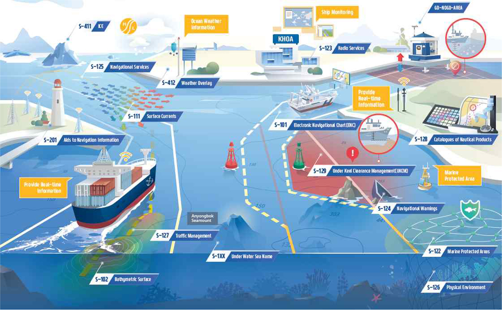
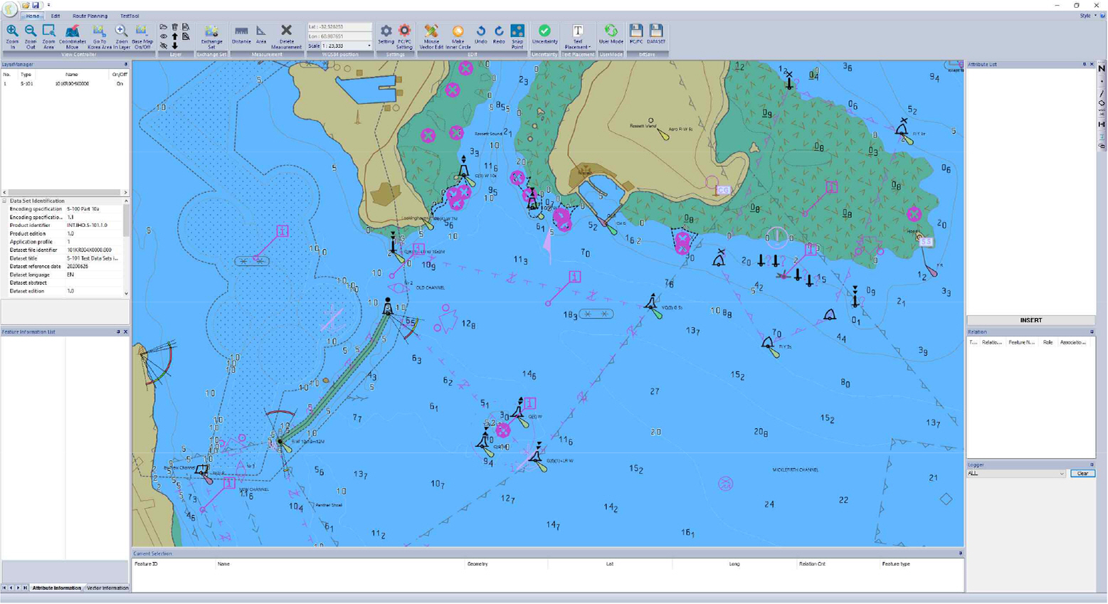
S-100 ECDIS can provide multiple maritime information, including ENCs and hydrographic information on a single screen through a harmonized overlay method, to mariners. Fig. 1 shows the hydrographic data developed with S-100. The S-57 ECDIS supports only ENCs; therefore, the ship sailors have to check the ship's operation by checking the tidal stream under keel clearance (UKC) and other maritime information through NAVTEX, facsimile, and publication papers.
The S-100 ECDIS can provide detailed bathymetric data, marine safety information (MSI), and weather forecast data in one step. However, S-101 ENCs can be harmonized with real-time water elevation and tidal stream; thus, it is expected that safe areas where ships can operate will be extended.
Table 1 lists the product specifications that the IHO developed hydrographic data to harmonize with the ENCs. Each product specification is independent of the other product specifications; additionally, the IHO has continuously expanded and revised the standards. The International Association of Marine Aids to Navigation and Lighthouse Authorities (IALA), an international technical association, started to develop the S-200 series based on S-100 to enhance digital data management and information exchange. Table 2 lists the product specifications developed by international organizations or groups such as IALA, Inland Electronic Navigational Chart (IENC). As global warming has been accelerating, WMO-IOC Joint Technical Commission for Oceanography and Marine Meteorology (JCOMM) services ice information to transport freight and energy resources via the Northern Sea Routes (NSR) through ECDIS(Luong et al., 2019).
4. S-100 Testbed and Platform
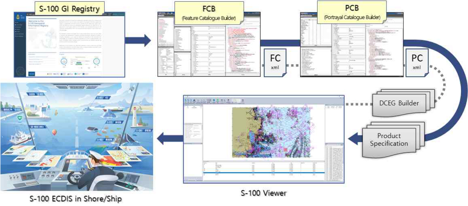
In this study, a machine-readable S-100 platform was developed to validate the concept of new standards and product specifications. Fig. 2 shows the platform operation flow chart designed in this research. The product specification developer must register all the information used in standards to the S-100 GI Registry. The information registered in the S-100 GI Registry is produced as a feature catalogue and portrayal catalogue through a catalogue builder; the catalogue sets operate as machine-readable standards for the ECDIS and Viewer. catalogue sets and standard documents corresponding to the product specification are produced and released in the form of a product specification package. When this version is revised using the platform, anyone can easily maintain the latest update by simply downloading the catalogue sets and latest product specification data and applying it to the S-100 ECDIS.
4.1 S-100 GI Registry
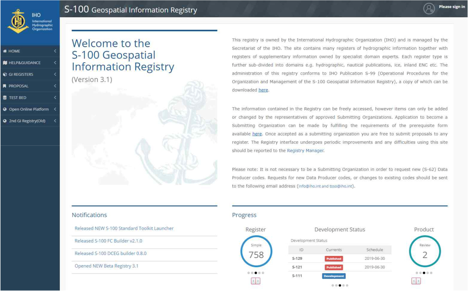
The IHO developed the S-100 GI Registry for the expansion and activation of various maritime product specifications based on the S-100 standard. The S-100 GI Registry contains geospatial information as features and attributes, including ENCs and hydrographic information. All information used in the ECDIS is defined in the form of features and attributes, which are registered and managed in the database. The navigation support systems such as ECDIS must use only the information registered in the S-100 GI Registry. When revision is made to the standard and S-100 GI Registry, the S-100 ECDIS users can download the latest product specification as digital files for machine-readable standards and simply import it into their own equipment. S-100 ECDIS users can use the latest product specifications without buying a new ECDIS or system source modification.
The S-100 GI Registry comprises the Concept Register, which manages common information and a data dictionary register for features and attributes for hydrographic information. Symbols for presenting ECDIS are managed by the Portrayal Register of the S-100 GI Registry.
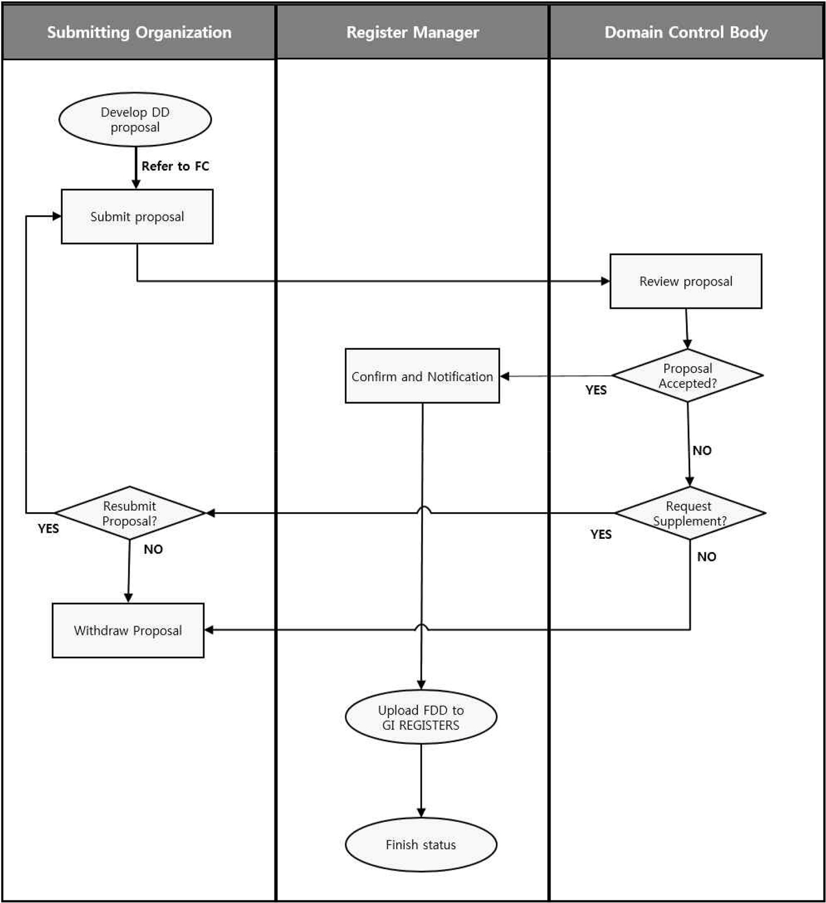
The S-100 GI Registry manages all product specifications from the IHO and distributes it to the users. When there is a revision in product specification or data model for standards, related catalogues should be updated and uploaded to the S-100 GI Registry. As the S-100 GI Registry comprises many registers of the hydrographic information together with registers of supplementary information owned by specialist domain experts, IHO designed an approval process for information such as features and symbols, as shown in Fig. 4.
4.2 Catalogue and Catalogue Builder
The feature catalogue is a conversion of the S-100 data model designed in unified modeling language (UML), which is a modeling language, into an electronic file as an extensible markup language (XML) so that the software can process it. The feature catalogue can be defined as a machine-readable standard, i.e., software can load and handle the data by itself.
The S-100 Feature catalogue Builder (FCB) is a tool used to create a feature catalogue required for geospatial information and feature data processing in S-100 S/W. The S-100 FCB creates a database by interlocking with the S-100 GI Registry, and the product specification developer binds the feature information registered in the database to produce the feature catalogue in the XML format. This includes features and information with geospatial information and associations corresponding to the relationship between items.
Portrayal is an expression of information that humans can understand. In the field of geographic information, drawing in the field of geographic information improves communication ability in a specific situation by utilizing one or more attribute information included in geographic information. The S-100 portrayal catalogue created by S-100 portrayal catalogue builder (PCB) was used for symbols and patterns in the ECDIS. The portrayal catalogue is a standard file, wherein the machine can process the S-10X application schema which can be produced by applying drawing standards for each feature type included in the feature catalogue. The catalogue for S-100 S/W can be defined as a set of feature catalogues and portrayal catalogues to present hydrographic data into related systems such as ECDIS and Viewer.
4.3 DCEG Builder
catalogue sets generated by the S-100 catalogue builder are machine-readable standards required to load and process data in the ECDIS. Data Classification and Encoding Guide (DCEG) builder is a tool for creating human-readable standards as document files for product specification developers and stakeholders to review the contents of the standard. Users can load existing feature catalogues into the DCEG builder and extract DCEG documents in the form of a template provided by the S-100 standard. The user can check the feature information and bound attribute by reviewing the extracted DCEG document.
5. Machine-readable Platform Development
In this study, a new machine-readable platform was designed to verify the PnP function defined in the S-100 standard; it was confirmed that the revision of the standard can be updated without negatively affecting the ECDIS users. The feature and attribute information required by the S-101 ENCs has been registered in the S-100 GI Registry, which is officially operated by the IHO. The S-101 feature catalogue was generated in the XML format by referring to the S-101 product specification and data model. The S-101 feature catalogue has the same contents and structure as the official version of the S-101 feature catalogue released by the IHO.
To verify symbol presentation through the S-100 Viewer, the S-101 portrayal catalogue was generated following the product specification and feature catalogue with the same symbol as the official version.
5.1 Standard Validation by S-100 Viewer
To verify catalogue sets for digital standards, the S-101 catalogue set and ENCs were loaded by KHOA S-100 Viewer, as shown in Fig. 5. The KHOA S-100 Viewer presented same features and symbols results which are defined in the current S-100 standard and S-101 product specifications.
In addition to checking the catalogue sets, NIWC Viewer was used to load the S-101 ENCs, as shown in Fig. 6 which was developed and released by NOAA and NIWC under United States of America.
As the product specification including catalogue sets were developed without being subordinated to Viewer and ECDIS, KHOA S-100 Viewer and NIWC Viewer expressed the color and shape of the symbol to be the same.
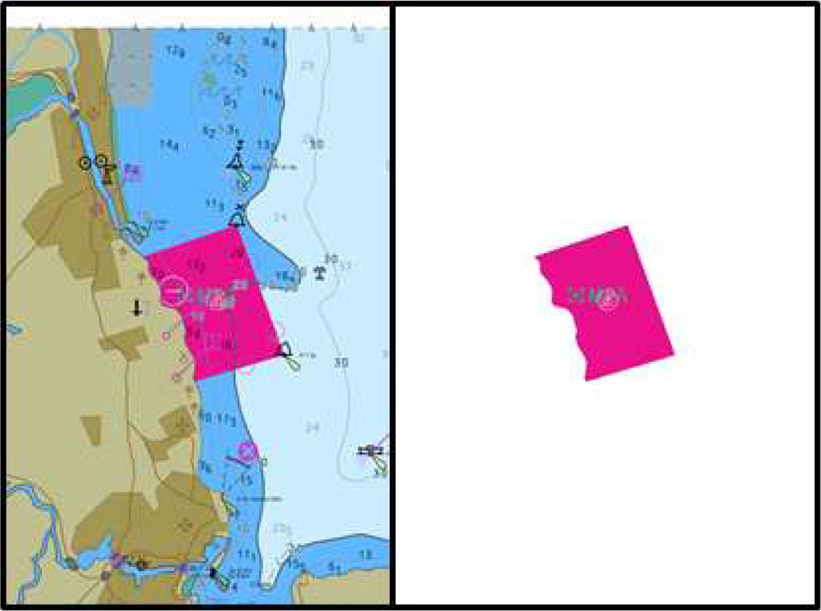
The IHO releases product specification version 1.0, which can be tested by actual Original Equipment Manufacturing (OEMs) when the standard completeness is of S-100 readiness 5 or higher. Fig. 7 shows the results of the S-122 marine protected area (MPA) data with product specification version 1.0. The S-122 MPA data were used to check whether the product specification and catalogue sets of hydrographic data other than S-101 ENCs are operating. It is verified that if users apply catalogue sets for machine-readable standards, not only ENCs but also other hydrographic information can be presented to Viewer and ECDIS.
5.2 Standard Updates through PnP
The most important function of PnP is that it should operate immediately, even if only files are replaced anytime and anywhere. In S-100 environments, the existing data should be loaded normally if only the catalogue sets are replaced, which reflects the standard's updates.
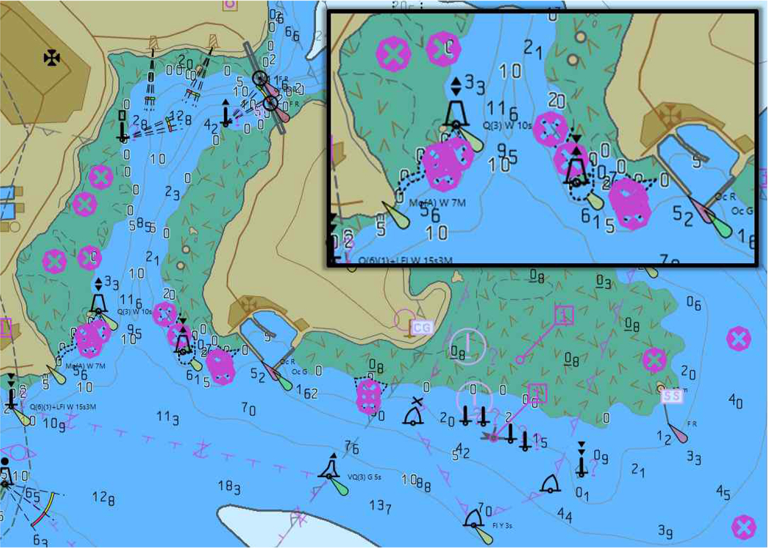
Fig. 8 shows a screenshot that loads the S-101 ENCs with the original catalogue sets. This shows the same display results as the existing S-57 ENCs. The three important safety information on the ship's voyage, Wreck, Obstruction, and Underwater Awash Rock features, are all red X-shaped symbols in use today.
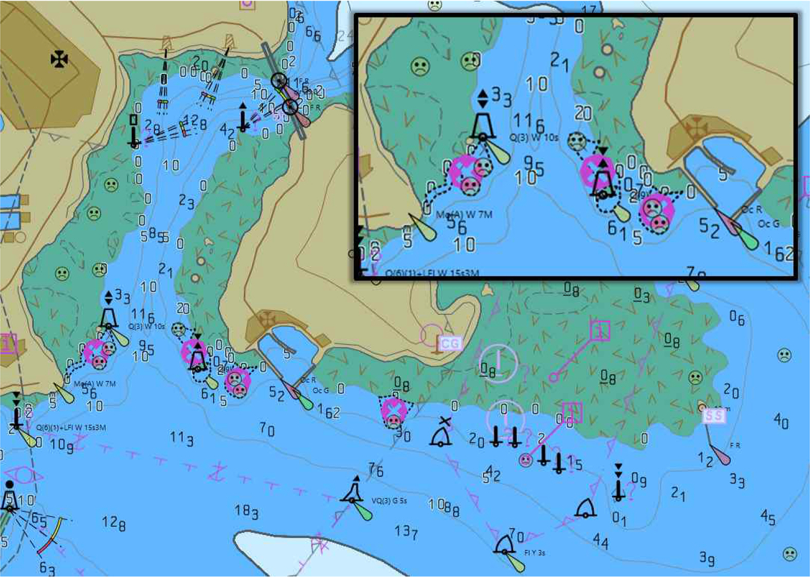
It was assumed that the symbol used in the S-101 ENCs was revised and updated, and the product specification new edition was released. The two features of wreck and underwater awash rock were replaced with the unhappy symbol that is usually used when the symbol was not yet developed by the IHO. The catalogue sets were updated, including new symbols. Fig. 9 shows the portrayal results of the S-101 ENCs using the updated product specification and catalogue sets.
As the Obstruction feature is not updated, it shows the existing X-shaped symbol as the original version. However, the Wreck and Under Awash Rock have another new symbol; they are expressed as unhappy symbols with updates.
In this study, PnP with a machine-readable concept was verified using different versions of the S-101 product specification. If the IHO revised standards for new data and information, the updated product specification will be uploaded to the S-100 GI Registry. S-100 ECDIS users can download the latest product specification as a machine-readable standard and apply it to their system without any source code modification or pay for new ECDIS.
6. Conclusion
In the presently available S-57 ENCs, the result could be different depending on the level of understanding of the developer as the standard has been developed in a human-readable format. In addition, even if the standard is updated, it is difficult to apply it to the ships operating worldwide because the ECDIS must be upgraded. The IHO recognized this problem and has prohibited the revision of the S-57 since 2000 and has remained frozen until the present day. Considering the limitations of S-57, the S-100 standard was developed based on the ISO 19100 series rather than an update of the S-57. The S-10X product specification, which is derived from the S-100 standard, can process data in real time, grid and tile data as well as ENCs, weather forecasts, and navigation information.
In this study, the concept and new methodology of the S-100 developed by the IHO were verified from four perspectives.
ŌæĀ Verification of the S-101 ENCs and S-122 MPA as hydrographic information.
ŌæĪ Providing the same standard and data enables the Viewers to display the same result regardless of the equipment manufacturer.
Ōæó If the standard is updated, it reflects product specifications such as catalogue sets; the user replaces only these files to apply the latest standard.
ŌæŻ Develop a machine-readable platform to enhance the activation of the standard
As the S-100 is not only utilized for the ENCs, but also a universal hydrographic data model adopted to expand product specification; S-101 ENCs and S-122 MPA were validated by Viewer. The second perspective is that of the PnP. When the standard is updated, users can easily change the latest standard without modifying the program of the equipment manufacturer or rebuilding the source code. The same version of catalogue sets was applied to the KHOA S-100 Viewer from the Republic of KOREA and NIWC Viewer from the USA. Both viewers displayed the same symbol, color, line, and pattern as they loaded the S-101 ENCs.
The third is the application of the latest catalogue sets according to the standard update. The standard was updated by changing the symbol of two features, wreck and underwater awash rock, as unhappy symbols. Therefore, it was confirmed that only two features were unhappy. By simply replacing the catalogue sets using the PnP concept, users can use the latest standards in their ECDIS without purchasing new S/W or updates.
The last perspective is the development of a machine-readable platform for S-100 and S-10X product specifications. The platform designed based on machine-readable is implemented in one environment, from standard born (development and creation) to growth (updates and revision), and management and release. The product specification developer distributes the official version developed in the S-100 GI Registry, and the navigation equipment users freely download it and build a cycle and ecosystem that applies to their equipment. Unlike the human-readable standard in the past, the machine-readable standard will keep the equipment up to date on ships, and it is believed that standard developers and stakeholders will quickly spread and activate the standard.
IHO developed a master plan to start the official production of S-101 ENCs from 2022 to activate S-101 ENCs and hydrographic information. S-57 and S-101 will be produced in parallel by 2027, and only S-101 will be produced from 2028. However, the IMO, ECDIS manufacturers, and shipping companies corresponding to OEMs delay decisions due to the completeness of standards, economic difficulties, and the need for training on new equipment. When the S-101 ENCs and S-10X hydrographic information begin to be utilized with ECDIS, a machine-readable platform will be needed in various fields. In the future, when the standard is revised, it will be necessary to study the function of automatically downloading and applying the latest standard to navigation equipment by linking maritime wireless communication and platforms in API.

 PDF Links
 PubReader
 ePub Link
 Full text via DOI
 Download Citation
 Print
Print


